You are here: Home > Network List > KN - Kyrgyz Seismic Telemetry Network Stations List
> Station TKM2 KN.TKM2 > Earthquake Result Viewer
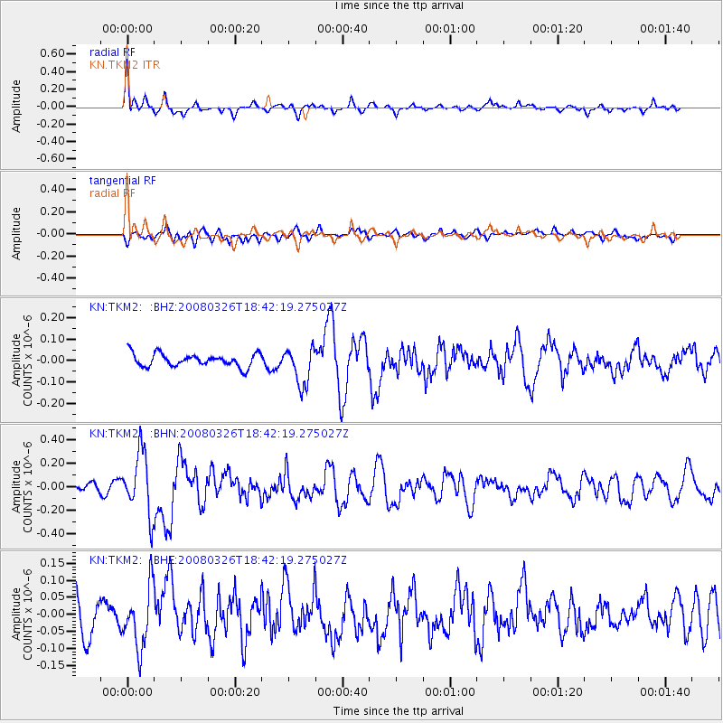
TKM2 KN.TKM2 - Earthquake Result Viewer
*The percent match for this event was below the threshold and hence no stack was calculated.
| Earthquake location: |
Kuril Islands |
| Earthquake latitude/longitude: |
46.4/153.0 |
| Earthquake time(UTC): |
2008/03/26 (086) 18:33:34 GMT |
| Earthquake Depth: |
17 km |
| Earthquake Magnitude: |
5.5 MB, 5.2 MS, 5.6 MW, 5.5 MW |
| Earthquake Catalog/Contributor: |
WHDF/NEIC |
|
| Network: |
KN Kyrgyz Seismic Telemetry Network |
| Station: |
TKM2 KN.TKM2 |
| Lat/Lon: |
42.92 N/75.60 E |
| Elevation: |
2020 m |
|
| Distance: |
53.1 deg |
| Az: |
296.247 deg |
| Baz: |
57.623 deg |
| Ray Param: |
$rayparam |
*The percent match for this event was below the threshold and hence was not used in the summary stack. |
|
| Radial Match: |
64.99096 % |
| Radial Bump: |
331 |
| Transverse Match: |
55.29714 % |
| Transverse Bump: |
400 |
| SOD ConfigId: |
2504 |
| Insert Time: |
2010-03-08 21:16:27.383 +0000 |
| GWidth: |
2.5 |
| Max Bumps: |
400 |
| Tol: |
0.001 |
|
Signal To Noise
| Channel | StoN | STA | LTA |
| KN:TKM2: :BHN:20080326T18:42:19.275027Z | 5.9865136 | 2.642866E-7 | 4.4146997E-8 |
| KN:TKM2: :BHE:20080326T18:42:19.275027Z | 1.7279594 | 8.8824976E-8 | 5.140455E-8 |
| KN:TKM2: :BHZ:20080326T18:42:19.275027Z | 2.9815567 | 8.9845614E-8 | 3.0133794E-8 |
| Arrivals |
| Ps | |
| PpPs | |
| PsPs/PpSs | |


