You are here: Home > Network List > KN - Kyrgyz Seismic Telemetry Network Stations List
> Station TKM2 KN.TKM2 > Earthquake Result Viewer
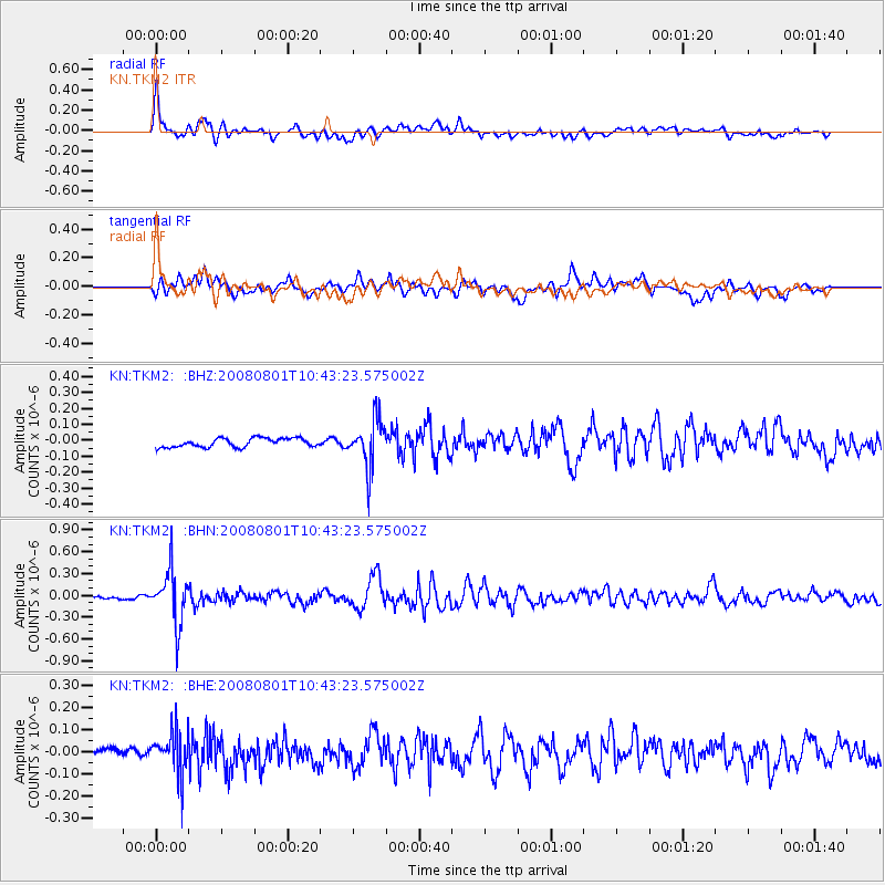
TKM2 KN.TKM2 - Earthquake Result Viewer
*The percent match for this event was below the threshold and hence no stack was calculated.
| Earthquake location: |
Mindoro, Philippines |
| Earthquake latitude/longitude: |
13.5/120.8 |
| Earthquake time(UTC): |
2008/08/01 (214) 10:35:24 GMT |
| Earthquake Depth: |
135 km |
| Earthquake Magnitude: |
5.6 MW, 5.3 MB, 5.5 MW |
| Earthquake Catalog/Contributor: |
WHDF/NEIC |
|
| Network: |
KN Kyrgyz Seismic Telemetry Network |
| Station: |
TKM2 KN.TKM2 |
| Lat/Lon: |
42.92 N/75.60 E |
| Elevation: |
2020 m |
|
| Distance: |
48.6 deg |
| Az: |
316.016 deg |
| Baz: |
113.142 deg |
| Ray Param: |
$rayparam |
*The percent match for this event was below the threshold and hence was not used in the summary stack. |
|
| Radial Match: |
76.65276 % |
| Radial Bump: |
400 |
| Transverse Match: |
60.104836 % |
| Transverse Bump: |
400 |
| SOD ConfigId: |
2504 |
| Insert Time: |
2010-03-08 21:16:30.102 +0000 |
| GWidth: |
2.5 |
| Max Bumps: |
400 |
| Tol: |
0.001 |
|
Signal To Noise
| Channel | StoN | STA | LTA |
| KN:TKM2: :BHN:20080801T10:43:23.575002Z | 11.872544 | 3.6271098E-7 | 3.05504E-8 |
| KN:TKM2: :BHE:20080801T10:43:23.575002Z | 2.5723996 | 9.861927E-8 | 3.833746E-8 |
| KN:TKM2: :BHZ:20080801T10:43:23.575002Z | 5.3449216 | 1.4840646E-7 | 2.7765882E-8 |
| Arrivals |
| Ps | |
| PpPs | |
| PsPs/PpSs | |


