You are here: Home > Network List > KN - Kyrgyz Seismic Telemetry Network Stations List
> Station TKM2 KN.TKM2 > Earthquake Result Viewer
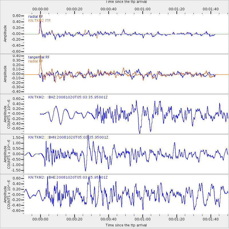
TKM2 KN.TKM2 - Earthquake Result Viewer
*The percent match for this event was below the threshold and hence no stack was calculated.
| Earthquake location: |
Minahassa Peninsula, Sulawesi |
| Earthquake latitude/longitude: |
0.1/120.7 |
| Earthquake time(UTC): |
2008/10/20 (294) 04:54:19 GMT |
| Earthquake Depth: |
102 km |
| Earthquake Magnitude: |
6.1 MB, 5.9 MW, 5.8 MW |
| Earthquake Catalog/Contributor: |
WHDF/NEIC |
|
| Network: |
KN Kyrgyz Seismic Telemetry Network |
| Station: |
TKM2 KN.TKM2 |
| Lat/Lon: |
42.92 N/75.60 E |
| Elevation: |
2020 m |
|
| Distance: |
58.7 deg |
| Az: |
322.498 deg |
| Baz: |
124.027 deg |
| Ray Param: |
$rayparam |
*The percent match for this event was below the threshold and hence was not used in the summary stack. |
|
| Radial Match: |
60.409874 % |
| Radial Bump: |
400 |
| Transverse Match: |
53.1346 % |
| Transverse Bump: |
400 |
| SOD ConfigId: |
2556 |
| Insert Time: |
2010-03-08 21:16:32.178 +0000 |
| GWidth: |
2.5 |
| Max Bumps: |
400 |
| Tol: |
0.001 |
|
Signal To Noise
| Channel | StoN | STA | LTA |
| KN:TKM2: :BHN:20081020T05:03:35.95001Z | 4.8590646 | 4.2704914E-7 | 8.788711E-8 |
| KN:TKM2: :BHE:20081020T05:03:35.95001Z | 1.775089 | 2.0306453E-7 | 1.1439682E-7 |
| KN:TKM2: :BHZ:20081020T05:03:35.95001Z | 0.76083475 | 1.2211855E-7 | 1.60506E-7 |
| Arrivals |
| Ps | |
| PpPs | |
| PsPs/PpSs | |


