You are here: Home > Network List > KN - Kyrgyz Seismic Telemetry Network Stations List
> Station TKM2 KN.TKM2 > Earthquake Result Viewer
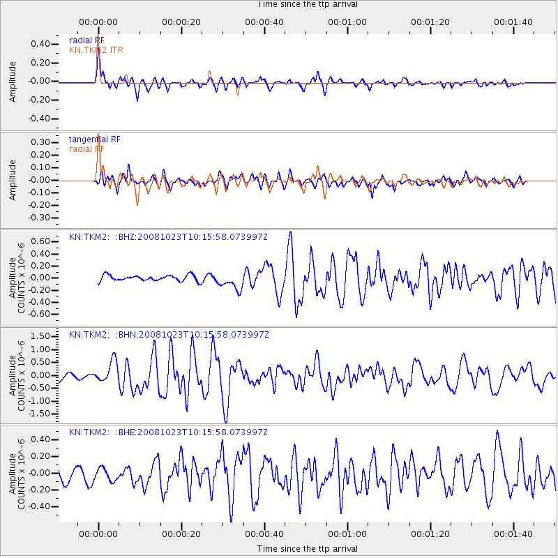
TKM2 KN.TKM2 - Earthquake Result Viewer
*The percent match for this event was below the threshold and hence no stack was calculated.
| Earthquake location: |
Admiralty Islands Region, P.N.G. |
| Earthquake latitude/longitude: |
-2.6/145.6 |
| Earthquake time(UTC): |
2008/10/23 (297) 10:04:35 GMT |
| Earthquake Depth: |
10 km |
| Earthquake Magnitude: |
6.0 MB, 6.3 MS, 6.3 MW, 6.3 MW |
| Earthquake Catalog/Contributor: |
WHDF/NEIC |
|
| Network: |
KN Kyrgyz Seismic Telemetry Network |
| Station: |
TKM2 KN.TKM2 |
| Lat/Lon: |
42.92 N/75.60 E |
| Elevation: |
2020 m |
|
| Distance: |
77.3 deg |
| Az: |
314.964 deg |
| Baz: |
105.802 deg |
| Ray Param: |
$rayparam |
*The percent match for this event was below the threshold and hence was not used in the summary stack. |
|
| Radial Match: |
78.78468 % |
| Radial Bump: |
400 |
| Transverse Match: |
70.77633 % |
| Transverse Bump: |
400 |
| SOD ConfigId: |
2556 |
| Insert Time: |
2010-03-08 21:16:33.687 +0000 |
| GWidth: |
2.5 |
| Max Bumps: |
400 |
| Tol: |
0.001 |
|
Signal To Noise
| Channel | StoN | STA | LTA |
| KN:TKM2: :BHN:20081023T10:15:58.073997Z | 3.581007 | 4.3273468E-7 | 1.2084162E-7 |
| KN:TKM2: :BHE:20081023T10:15:58.073997Z | 0.6209381 | 7.518095E-8 | 1.210764E-7 |
| KN:TKM2: :BHZ:20081023T10:15:58.073997Z | 3.167921 | 1.4852345E-7 | 4.688357E-8 |
| Arrivals |
| Ps | |
| PpPs | |
| PsPs/PpSs | |


