You are here: Home > Network List > KN - Kyrgyz Seismic Telemetry Network Stations List
> Station TKM2 KN.TKM2 > Earthquake Result Viewer
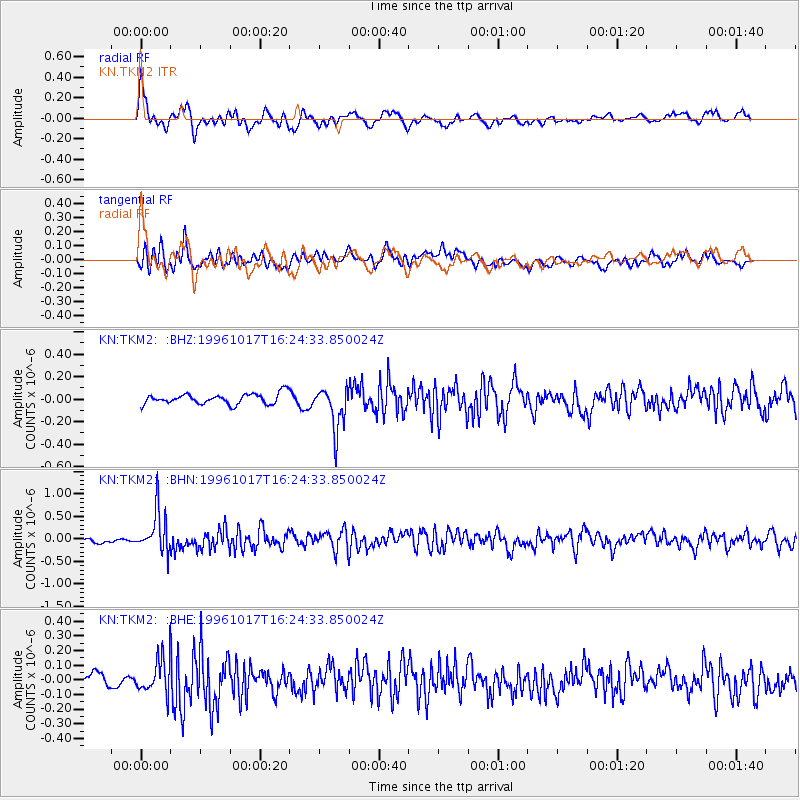
TKM2 KN.TKM2 - Earthquake Result Viewer
*The percent match for this event was below the threshold and hence no stack was calculated.
| Earthquake location: |
Mindanao, Philippines |
| Earthquake latitude/longitude: |
5.7/125.9 |
| Earthquake time(UTC): |
1996/10/17 (291) 16:15:25 GMT |
| Earthquake Depth: |
117 km |
| Earthquake Magnitude: |
5.7 MB, 5.9 UNKNOWN, 5.9 MW |
| Earthquake Catalog/Contributor: |
WHDF/NEIC |
|
| Network: |
KN Kyrgyz Seismic Telemetry Network |
| Station: |
TKM2 KN.TKM2 |
| Lat/Lon: |
42.92 N/75.60 E |
| Elevation: |
2020 m |
|
| Distance: |
57.8 deg |
| Az: |
318.036 deg |
| Baz: |
115.066 deg |
| Ray Param: |
$rayparam |
*The percent match for this event was below the threshold and hence was not used in the summary stack. |
|
| Radial Match: |
72.83256 % |
| Radial Bump: |
400 |
| Transverse Match: |
75.50611 % |
| Transverse Bump: |
400 |
| SOD ConfigId: |
4480 |
| Insert Time: |
2010-03-08 21:16:40.911 +0000 |
| GWidth: |
2.5 |
| Max Bumps: |
400 |
| Tol: |
0.001 |
|
Signal To Noise
| Channel | StoN | STA | LTA |
| KN:TKM2: :BHN:19961017T16:24:33.850024Z | 5.971045 | 4.5431312E-7 | 7.608603E-8 |
| KN:TKM2: :BHE:19961017T16:24:33.850024Z | 2.2346249 | 1.17577954E-7 | 5.2616418E-8 |
| KN:TKM2: :BHZ:19961017T16:24:33.850024Z | 4.072627 | 1.8901657E-7 | 4.6411465E-8 |
| Arrivals |
| Ps | |
| PpPs | |
| PsPs/PpSs | |


