You are here: Home > Network List > TS - TERRAscope (Southern California Seismic Network) Stations List
> Station VTV Victorville, California, USA > Earthquake Result Viewer
VTV Victorville, California, USA - Earthquake Result Viewer

| Earthquake location: |
Santa Cruz Islands |
| Earthquake latitude/longitude: |
-10.8/166.2 |
| Earthquake time(UTC): |
1994/09/01 (244) 15:38:55 GMT |
| Earthquake Depth: |
154 km |
| Earthquake Magnitude: |
5.7 MB |
| Earthquake Catalog/Contributor: |
WHDF/NEIC |
|
| Network: |
TS TERRAscope (Southern California Seismic Network) |
| Station: |
VTV Victorville, California, USA |
| Lat/Lon: |
34.57 N/117.33 W |
| Elevation: |
847 m |
|
| Distance: |
85.2 deg |
| Az: |
53.631 deg |
| Baz: |
253.456 deg |
| Ray Param: |
0.04460297 |
| Estimated Moho Depth: |
67.5 km |
| Estimated Crust Vp/Vs: |
1.86 |
| Assumed Crust Vp: |
6.276 km/s |
| Estimated Crust Vs: |
3.374 km/s |
| Estimated Crust Poisson's Ratio: |
0.30 |
|
| Radial Match: |
83.38898 % |
| Radial Bump: |
388 |
| Transverse Match: |
54.61666 % |
| Transverse Bump: |
400 |
| SOD ConfigId: |
17000 |
| Insert Time: |
2010-02-26 14:53:52.707 +0000 |
| GWidth: |
2.5 |
| Max Bumps: |
400 |
| Tol: |
0.001 |
|
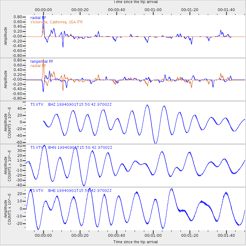
Signal To Noise
| Channel | StoN | STA | LTA |
| TS:VTV: :BHN:19940901T15:50:42.97002Z | 3.2411237 | 2.9279381E-5 | 9.033713E-6 |
| TS:VTV: :BHE:19940901T15:50:42.97002Z | 0.39522725 | 5.6609E-6 | 1.4323153E-5 |
| TS:VTV: :BHZ:19940901T15:50:42.97002Z | 1.2849942 | 2.5950423E-5 | 2.0194973E-5 |
| Arrivals |
| Ps | 9.5 SECOND |
| PpPs | 30 SECOND |
| PsPs/PpSs | 40 SECOND |


