You are here: Home > Network List > KN - Kyrgyz Seismic Telemetry Network Stations List
> Station TKM2 KN.TKM2 > Earthquake Result Viewer
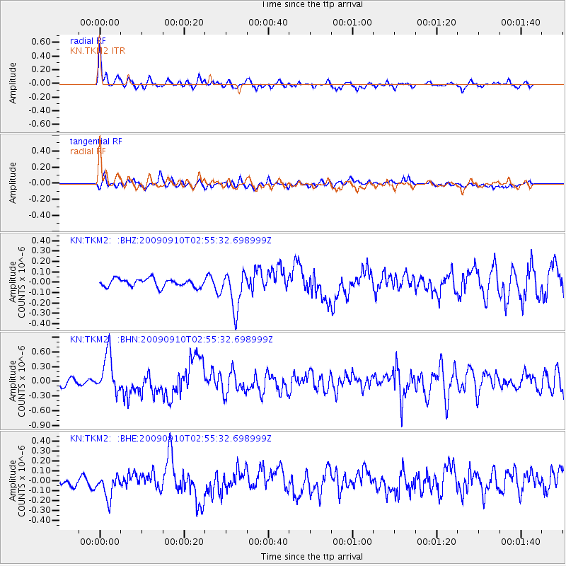
TKM2 KN.TKM2 - Earthquake Result Viewer
*The percent match for this event was below the threshold and hence no stack was calculated.
| Earthquake location: |
Kuril Islands |
| Earthquake latitude/longitude: |
48.3/154.2 |
| Earthquake time(UTC): |
2009/09/10 (253) 02:46:50 GMT |
| Earthquake Depth: |
36 km |
| Earthquake Magnitude: |
6.0 MB, 5.5 MS, 6.0 MW, 5.8 MW |
| Earthquake Catalog/Contributor: |
WHDF/NEIC |
|
| Network: |
KN Kyrgyz Seismic Telemetry Network |
| Station: |
TKM2 KN.TKM2 |
| Lat/Lon: |
42.92 N/75.60 E |
| Elevation: |
2020 m |
|
| Distance: |
53.0 deg |
| Az: |
295.585 deg |
| Baz: |
55.044 deg |
| Ray Param: |
$rayparam |
*The percent match for this event was below the threshold and hence was not used in the summary stack. |
|
| Radial Match: |
73.76675 % |
| Radial Bump: |
397 |
| Transverse Match: |
64.435905 % |
| Transverse Bump: |
400 |
| SOD ConfigId: |
2622 |
| Insert Time: |
2010-03-08 21:16:46.673 +0000 |
| GWidth: |
2.5 |
| Max Bumps: |
400 |
| Tol: |
0.001 |
|
Signal To Noise
| Channel | StoN | STA | LTA |
| KN:TKM2: :BHN:20090910T02:55:32.698999Z | 6.3657556 | 4.0767225E-7 | 6.404145E-8 |
| KN:TKM2: :BHE:20090910T02:55:32.698999Z | 2.4624615 | 1.1768027E-7 | 4.778969E-8 |
| KN:TKM2: :BHZ:20090910T02:55:32.698999Z | 4.8654146 | 1.8788529E-7 | 3.86165E-8 |
| Arrivals |
| Ps | |
| PpPs | |
| PsPs/PpSs | |


