You are here: Home > Network List > OX - North-East Italy Seismic Network Stations List
> Station DRE Drenchia > Earthquake Result Viewer
DRE Drenchia - Earthquake Result Viewer
| Earthquake location: |
Ryukyu Islands, Japan |
| Earthquake latitude/longitude: |
28.9/128.3 |
| Earthquake time(UTC): |
2020/06/13 (165) 15:51:23 GMT |
| Earthquake Depth: |
160 km |
| Earthquake Magnitude: |
6.6 Mww |
| Earthquake Catalog/Contributor: |
NEIC PDE/us |
|
| Network: |
OX North-East Italy Seismic Network |
| Station: |
DRE Drenchia |
| Lat/Lon: |
46.17 N/13.65 E |
| Elevation: |
810 m |
|
| Distance: |
84.7 deg |
| Az: |
320.62 deg |
| Baz: |
53.156 deg |
| Ray Param: |
0.044929728 |
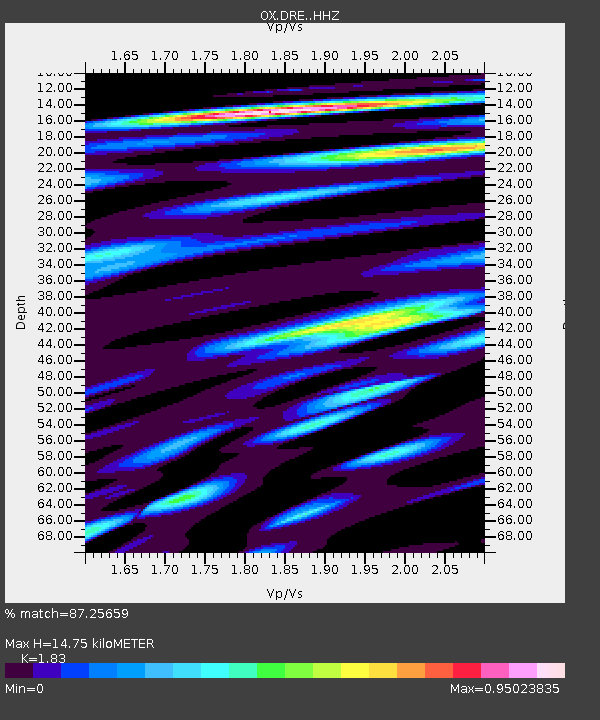
| Estimated Moho Depth: |
14.75 km |
| Estimated Crust Vp/Vs: |
1.83 |
| Assumed Crust Vp: |
6.35 km/s |
| Estimated Crust Vs: |
3.47 km/s |
| Estimated Crust Poisson's Ratio: |
0.29 |
|
| Radial Match: |
87.25659 % |
| Radial Bump: |
400 |
| Transverse Match: |
90.64476 % |
| Transverse Bump: |
400 |
| SOD ConfigId: |
21709731 |
| Insert Time: |
2020-06-27 16:10:34.659 +0000 |
| GWidth: |
2.5 |
| Max Bumps: |
400 |
| Tol: |
0.001 |
|

Signal To Noise
| Channel | StoN | STA | LTA |
| OX:DRE: :HHZ:20200613T16:03:08.110004Z | 20.717884 | 1.9451763E-6 | 9.388876E-8 |
| OX:DRE: :HHN:20200613T16:03:08.110004Z | 7.159421 | 4.8171677E-7 | 6.728432E-8 |
| OX:DRE: :HHE:20200613T16:03:08.110004Z | 14.814455 | 5.768037E-7 | 3.8935195E-8 |
| Arrivals |
| Ps | 2.0 SECOND |
| PpPs | 6.4 SECOND |
| PsPs/PpSs | 8.4 SECOND |


