You are here: Home > Network List > KN - Kyrgyz Seismic Telemetry Network Stations List
> Station TKM2 KN.TKM2 > Earthquake Result Viewer
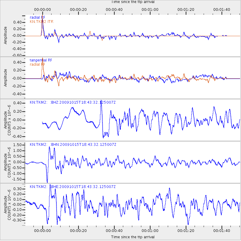
TKM2 KN.TKM2 - Earthquake Result Viewer
*The percent match for this event was below the threshold and hence no stack was calculated.
| Earthquake location: |
Sulawesi, Indonesia |
| Earthquake latitude/longitude: |
-3.6/123.2 |
| Earthquake time(UTC): |
2009/10/15 (288) 18:33:36 GMT |
| Earthquake Depth: |
17 km |
| Earthquake Magnitude: |
6.0 MB, 5.3 MS, 5.7 MW, 5.7 MW |
| Earthquake Catalog/Contributor: |
WHDF/NEIC |
|
| Network: |
KN Kyrgyz Seismic Telemetry Network |
| Station: |
TKM2 KN.TKM2 |
| Lat/Lon: |
42.92 N/75.60 E |
| Elevation: |
2020 m |
|
| Distance: |
63.1 deg |
| Az: |
322.567 deg |
| Baz: |
124.327 deg |
| Ray Param: |
$rayparam |
*The percent match for this event was below the threshold and hence was not used in the summary stack. |
|
| Radial Match: |
74.43708 % |
| Radial Bump: |
400 |
| Transverse Match: |
65.86882 % |
| Transverse Bump: |
400 |
| SOD ConfigId: |
2622 |
| Insert Time: |
2010-03-08 21:16:51.570 +0000 |
| GWidth: |
2.5 |
| Max Bumps: |
400 |
| Tol: |
0.001 |
|
Signal To Noise
| Channel | StoN | STA | LTA |
| KN:TKM2: :BHN:20091015T18:43:32.125007Z | 10.224611 | 7.287798E-7 | 7.127702E-8 |
| KN:TKM2: :BHE:20091015T18:43:32.125007Z | 3.6632655 | 2.0052889E-7 | 5.4740475E-8 |
| KN:TKM2: :BHZ:20091015T18:43:32.125007Z | 1.746316 | 2.6461475E-7 | 1.5152743E-7 |
| Arrivals |
| Ps | |
| PpPs | |
| PsPs/PpSs | |


