You are here: Home > Network List > TA - USArray Transportable Network (new EarthScope stations) Stations List
> Station A19K Wainwright, AK, USA > Earthquake Result Viewer
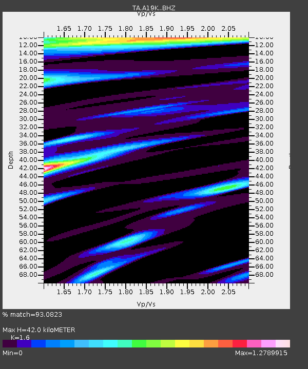
A19K Wainwright, AK, USA - Earthquake Result Viewer
| Earthquake location: |
Ryukyu Islands, Japan |
| Earthquake latitude/longitude: |
28.9/128.3 |
| Earthquake time(UTC): |
2020/06/13 (165) 15:51:23 GMT |
| Earthquake Depth: |
160 km |
| Earthquake Magnitude: |
6.6 Mww |
| Earthquake Catalog/Contributor: |
NEIC PDE/us |
|
| Network: |
TA USArray Transportable Network (new EarthScope stations) |
| Station: |
A19K Wainwright, AK, USA |
| Lat/Lon: |
70.20 N/161.07 W |
| Elevation: |
24 m |
|
| Distance: |
56.5 deg |
| Az: |
22.666 deg |
| Baz: |
262.505 deg |
| Ray Param: |
0.06356994 |
| Estimated Moho Depth: |
42.0 km |
| Estimated Crust Vp/Vs: |
1.60 |
| Assumed Crust Vp: |
5.989 km/s |
| Estimated Crust Vs: |
3.743 km/s |
| Estimated Crust Poisson's Ratio: |
0.18 |
|
| Radial Match: |
93.0823 % |
| Radial Bump: |
388 |
| Transverse Match: |
86.0538 % |
| Transverse Bump: |
400 |
| SOD ConfigId: |
21709731 |
| Insert Time: |
2020-06-27 16:13:13.431 +0000 |
| GWidth: |
2.5 |
| Max Bumps: |
400 |
| Tol: |
0.001 |
|

Signal To Noise
| Channel | StoN | STA | LTA |
| TA:A19K: :BHZ:20200613T16:00:18.375019Z | 12.256647 | 1.1422508E-6 | 9.3194394E-8 |
| TA:A19K: :BHN:20200613T16:00:18.375019Z | 1.1973789 | 9.293197E-8 | 7.761283E-8 |
| TA:A19K: :BHE:20200613T16:00:18.375019Z | 4.93337 | 4.048672E-7 | 8.206706E-8 |
| Arrivals |
| Ps | 4.4 SECOND |
| PpPs | 17 SECOND |
| PsPs/PpSs | 22 SECOND |


