You are here: Home > Network List > TA - USArray Transportable Network (new EarthScope stations) Stations List
> Station C23K Itkillik River, AK, USA > Earthquake Result Viewer
C23K Itkillik River, AK, USA - Earthquake Result Viewer
| Earthquake location: |
Ryukyu Islands, Japan |
| Earthquake latitude/longitude: |
28.9/128.3 |
| Earthquake time(UTC): |
2020/06/13 (165) 15:51:23 GMT |
| Earthquake Depth: |
160 km |
| Earthquake Magnitude: |
6.6 Mww |
| Earthquake Catalog/Contributor: |
NEIC PDE/us |
|
| Network: |
TA USArray Transportable Network (new EarthScope stations) |
| Station: |
C23K Itkillik River, AK, USA |
| Lat/Lon: |
69.84 N/150.61 W |
| Elevation: |
179 m |
|
| Distance: |
60.1 deg |
| Az: |
23.277 deg |
| Baz: |
272.65 deg |
| Ray Param: |
0.061266508 |
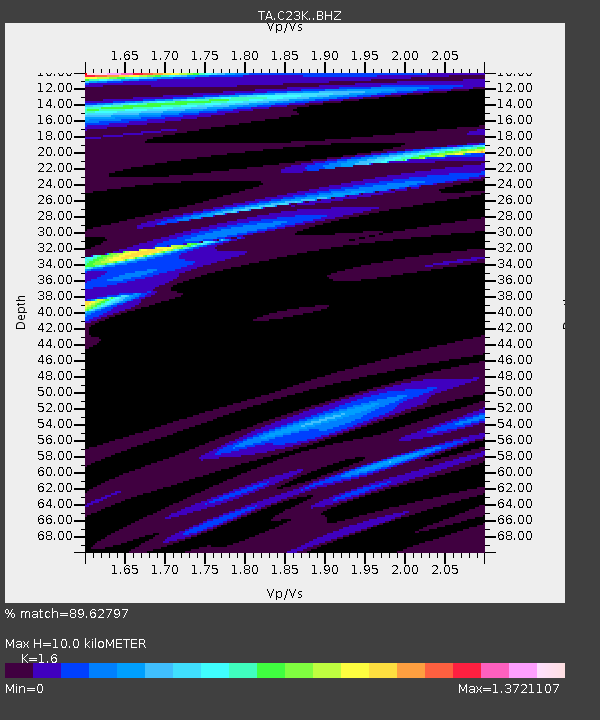
| Estimated Moho Depth: |
10.0 km |
| Estimated Crust Vp/Vs: |
1.60 |
| Assumed Crust Vp: |
6.221 km/s |
| Estimated Crust Vs: |
3.888 km/s |
| Estimated Crust Poisson's Ratio: |
0.18 |
|
| Radial Match: |
89.62797 % |
| Radial Bump: |
345 |
| Transverse Match: |
82.41991 % |
| Transverse Bump: |
388 |
| SOD ConfigId: |
21709731 |
| Insert Time: |
2020-06-27 16:13:27.742 +0000 |
| GWidth: |
2.5 |
| Max Bumps: |
400 |
| Tol: |
0.001 |
|

Signal To Noise
| Channel | StoN | STA | LTA |
| TA:C23K: :BHZ:20200613T16:00:43.07497Z | 18.022058 | 1.1673413E-6 | 6.477292E-8 |
| TA:C23K: :BHN:20200613T16:00:43.07497Z | 1.830125 | 1.0993335E-7 | 6.006877E-8 |
| TA:C23K: :BHE:20200613T16:00:43.07497Z | 7.371234 | 5.223265E-7 | 7.086012E-8 |
| Arrivals |
| Ps | 1.0 SECOND |
| PpPs | 4.0 SECOND |
| PsPs/PpSs | 5.0 SECOND |


