You are here: Home > Network List > TA - USArray Transportable Network (new EarthScope stations) Stations List
> Station D19K Kuna River, AK, USA > Earthquake Result Viewer
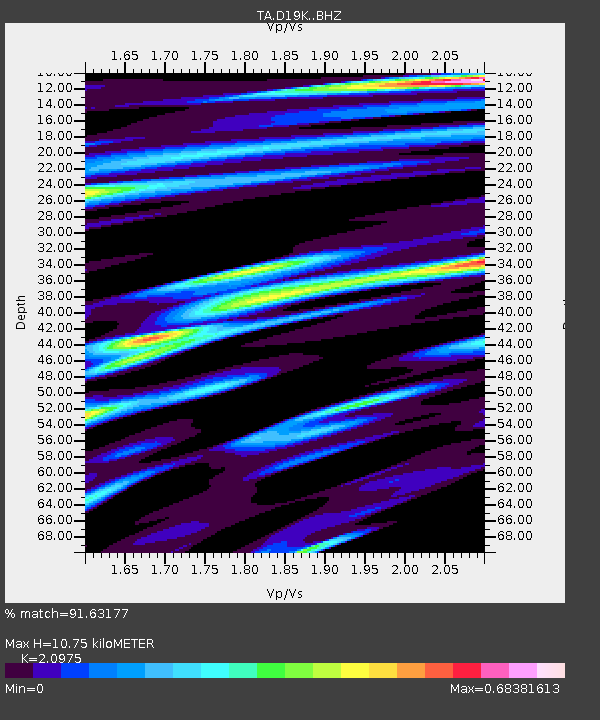
D19K Kuna River, AK, USA - Earthquake Result Viewer
| Earthquake location: |
Ryukyu Islands, Japan |
| Earthquake latitude/longitude: |
28.9/128.3 |
| Earthquake time(UTC): |
2020/06/13 (165) 15:51:23 GMT |
| Earthquake Depth: |
160 km |
| Earthquake Magnitude: |
6.6 Mww |
| Earthquake Catalog/Contributor: |
NEIC PDE/us |
|
| Network: |
TA USArray Transportable Network (new EarthScope stations) |
| Station: |
D19K Kuna River, AK, USA |
| Lat/Lon: |
68.49 N/158.12 W |
| Elevation: |
671 m |
|
| Distance: |
57.4 deg |
| Az: |
24.826 deg |
| Baz: |
266.446 deg |
| Ray Param: |
0.063003555 |
| Estimated Moho Depth: |
10.75 km |
| Estimated Crust Vp/Vs: |
2.10 |
| Assumed Crust Vp: |
6.221 km/s |
| Estimated Crust Vs: |
2.966 km/s |
| Estimated Crust Poisson's Ratio: |
0.35 |
|
| Radial Match: |
91.63177 % |
| Radial Bump: |
400 |
| Transverse Match: |
88.71756 % |
| Transverse Bump: |
400 |
| SOD ConfigId: |
21709731 |
| Insert Time: |
2020-06-27 16:13:36.274 +0000 |
| GWidth: |
2.5 |
| Max Bumps: |
400 |
| Tol: |
0.001 |
|

Signal To Noise
| Channel | StoN | STA | LTA |
| TA:D19K: :BHZ:20200613T16:00:24.550007Z | 17.029097 | 1.1466393E-6 | 6.733412E-8 |
| TA:D19K: :BHN:20200613T16:00:24.550007Z | 2.7465992 | 1.2927204E-7 | 4.706622E-8 |
| TA:D19K: :BHE:20200613T16:00:24.550007Z | 10.200713 | 4.941711E-7 | 4.844476E-8 |
| Arrivals |
| Ps | 2.0 SECOND |
| PpPs | 5.2 SECOND |
| PsPs/PpSs | 7.1 SECOND |


