You are here: Home > Network List > TA - USArray Transportable Network (new EarthScope stations) Stations List
> Station D23K Nanushuk River, AK USA > Earthquake Result Viewer
D23K Nanushuk River, AK USA - Earthquake Result Viewer
| Earthquake location: |
Ryukyu Islands, Japan |
| Earthquake latitude/longitude: |
28.9/128.3 |
| Earthquake time(UTC): |
2020/06/13 (165) 15:51:23 GMT |
| Earthquake Depth: |
160 km |
| Earthquake Magnitude: |
6.6 Mww |
| Earthquake Catalog/Contributor: |
NEIC PDE/us |
|
| Network: |
TA USArray Transportable Network (new EarthScope stations) |
| Station: |
D23K Nanushuk River, AK USA |
| Lat/Lon: |
68.97 N/150.68 W |
| Elevation: |
406 m |
|
| Distance: |
60.1 deg |
| Az: |
24.287 deg |
| Baz: |
273.09 deg |
| Ray Param: |
0.06125335 |
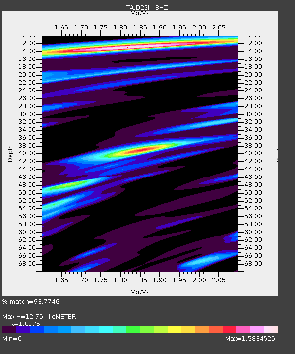
| Estimated Moho Depth: |
12.75 km |
| Estimated Crust Vp/Vs: |
1.82 |
| Assumed Crust Vp: |
6.221 km/s |
| Estimated Crust Vs: |
3.423 km/s |
| Estimated Crust Poisson's Ratio: |
0.28 |
|
| Radial Match: |
93.7746 % |
| Radial Bump: |
377 |
| Transverse Match: |
88.132286 % |
| Transverse Bump: |
400 |
| SOD ConfigId: |
21709731 |
| Insert Time: |
2020-06-27 16:13:39.467 +0000 |
| GWidth: |
2.5 |
| Max Bumps: |
400 |
| Tol: |
0.001 |
|

Signal To Noise
| Channel | StoN | STA | LTA |
| TA:D23K: :BHZ:20200613T16:00:43.224995Z | 19.199083 | 1.1862649E-6 | 6.178758E-8 |
| TA:D23K: :BHN:20200613T16:00:43.224995Z | 2.0996075 | 1.043176E-7 | 4.9684335E-8 |
| TA:D23K: :BHE:20200613T16:00:43.224995Z | 7.68866 | 4.8641147E-7 | 6.326349E-8 |
| Arrivals |
| Ps | 1.7 SECOND |
| PpPs | 5.5 SECOND |
| PsPs/PpSs | 7.3 SECOND |


