You are here: Home > Network List > KN - Kyrgyz Seismic Telemetry Network Stations List
> Station UCH KN.UCH > Earthquake Result Viewer
UCH KN.UCH - Earthquake Result Viewer

| Earthquake location: |
Hokkaido, Japan Region |
| Earthquake latitude/longitude: |
41.8/143.4 |
| Earthquake time(UTC): |
2009/06/05 (156) 03:30:33 GMT |
| Earthquake Depth: |
29 km |
| Earthquake Magnitude: |
6.0 MB, 6.3 MS, 6.4 MW, 6.4 MW |
| Earthquake Catalog/Contributor: |
WHDF/NEIC |
|
| Network: |
KN Kyrgyz Seismic Telemetry Network |
| Station: |
UCH KN.UCH |
| Lat/Lon: |
42.23 N/74.51 E |
| Elevation: |
3850 m |
|
| Distance: |
49.9 deg |
| Az: |
294.993 deg |
| Baz: |
65.795 deg |
| Ray Param: |
0.06836965 |
| Estimated Moho Depth: |
47.0 km |
| Estimated Crust Vp/Vs: |
2.01 |
| Assumed Crust Vp: |
6.306 km/s |
| Estimated Crust Vs: |
3.137 km/s |
| Estimated Crust Poisson's Ratio: |
0.34 |
|
| Radial Match: |
99.37747 % |
| Radial Bump: |
102 |
| Transverse Match: |
89.110664 % |
| Transverse Bump: |
363 |
| SOD ConfigId: |
2648 |
| Insert Time: |
2010-03-08 21:16:58.588 +0000 |
| GWidth: |
2.5 |
| Max Bumps: |
400 |
| Tol: |
0.001 |
|
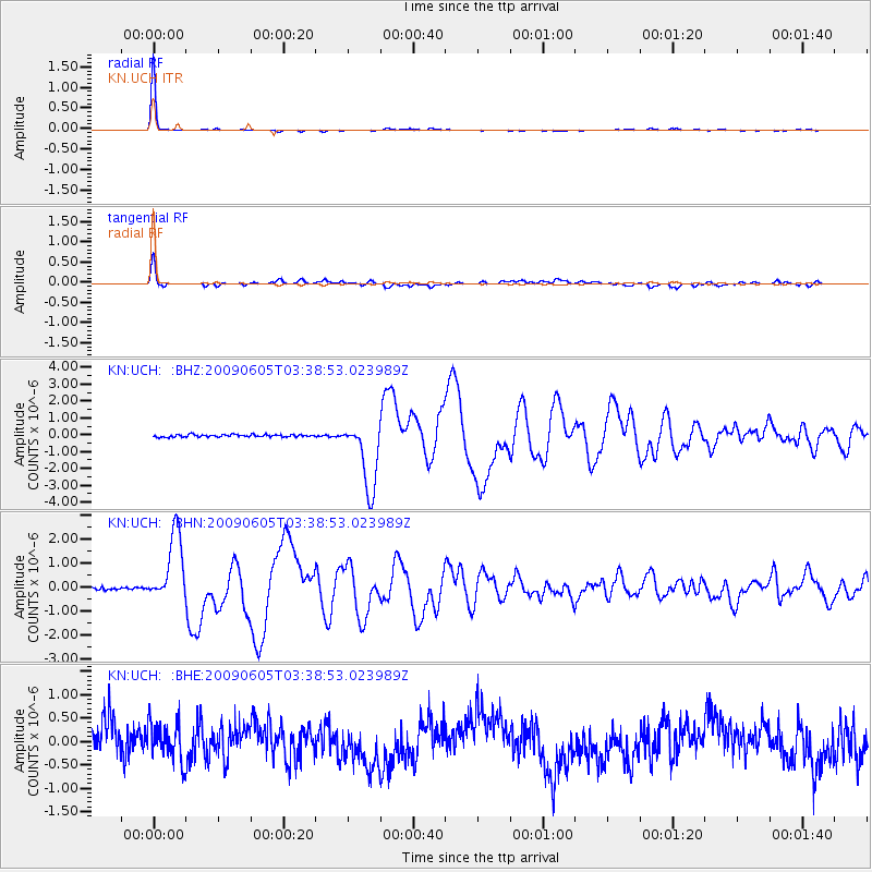
Signal To Noise
| Channel | StoN | STA | LTA |
| KN:UCH: :BHN:20090605T03:38:53.023989Z | 28.190956 | 1.4626016E-6 | 5.1881944E-8 |
| KN:UCH: :BHE:20090605T03:38:53.023989Z | 1.0853972 | 4.0302047E-7 | 3.713115E-7 |
| KN:UCH: :BHZ:20090605T03:38:53.023989Z | 29.888638 | 2.0716745E-6 | 6.931312E-8 |
| Arrivals |
| Ps | 7.9 SECOND |
| PpPs | 21 SECOND |
| PsPs/PpSs | 29 SECOND |


