You are here: Home > Network List > TA - USArray Transportable Network (new EarthScope stations) Stations List
> Station E29M Blow River, YT, CAN > Earthquake Result Viewer
E29M Blow River, YT, CAN - Earthquake Result Viewer
| Earthquake location: |
Ryukyu Islands, Japan |
| Earthquake latitude/longitude: |
28.9/128.3 |
| Earthquake time(UTC): |
2020/06/13 (165) 15:51:23 GMT |
| Earthquake Depth: |
160 km |
| Earthquake Magnitude: |
6.6 Mww |
| Earthquake Catalog/Contributor: |
NEIC PDE/us |
|
| Network: |
TA USArray Transportable Network (new EarthScope stations) |
| Station: |
E29M Blow River, YT, CAN |
| Lat/Lon: |
68.39 N/137.90 W |
| Elevation: |
324 m |
|
| Distance: |
64.8 deg |
| Az: |
24.105 deg |
| Baz: |
284.91 deg |
| Ray Param: |
0.05820895 |
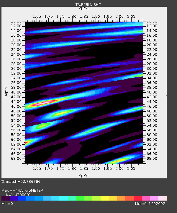
| Estimated Moho Depth: |
44.5 km |
| Estimated Crust Vp/Vs: |
1.67 |
| Assumed Crust Vp: |
5.981 km/s |
| Estimated Crust Vs: |
3.582 km/s |
| Estimated Crust Poisson's Ratio: |
0.22 |
|
| Radial Match: |
92.786766 % |
| Radial Bump: |
400 |
| Transverse Match: |
89.67916 % |
| Transverse Bump: |
400 |
| SOD ConfigId: |
21709731 |
| Insert Time: |
2020-06-27 16:14:01.599 +0000 |
| GWidth: |
2.5 |
| Max Bumps: |
400 |
| Tol: |
0.001 |
|

Signal To Noise
| Channel | StoN | STA | LTA |
| TA:E29M: :BHZ:20200613T16:01:14.32497Z | 16.418922 | 9.919702E-7 | 6.0416276E-8 |
| TA:E29M: :BHN:20200613T16:01:14.32497Z | 4.924804 | 1.5516319E-7 | 3.150647E-8 |
| TA:E29M: :BHE:20200613T16:01:14.32497Z | 8.4296665 | 4.418548E-7 | 5.241664E-8 |
| Arrivals |
| Ps | 5.2 SECOND |
| PpPs | 19 SECOND |
| PsPs/PpSs | 24 SECOND |


