You are here: Home > Network List > TA - USArray Transportable Network (new EarthScope stations) Stations List
> Station G29M Pine Creek, YT, CAN > Earthquake Result Viewer
G29M Pine Creek, YT, CAN - Earthquake Result Viewer
| Earthquake location: |
Ryukyu Islands, Japan |
| Earthquake latitude/longitude: |
28.9/128.3 |
| Earthquake time(UTC): |
2020/06/13 (165) 15:51:23 GMT |
| Earthquake Depth: |
160 km |
| Earthquake Magnitude: |
6.6 Mww |
| Earthquake Catalog/Contributor: |
NEIC PDE/us |
|
| Network: |
TA USArray Transportable Network (new EarthScope stations) |
| Station: |
G29M Pine Creek, YT, CAN |
| Lat/Lon: |
66.91 N/138.02 W |
| Elevation: |
572 m |
|
| Distance: |
65.2 deg |
| Az: |
25.699 deg |
| Baz: |
285.468 deg |
| Ray Param: |
0.057986353 |
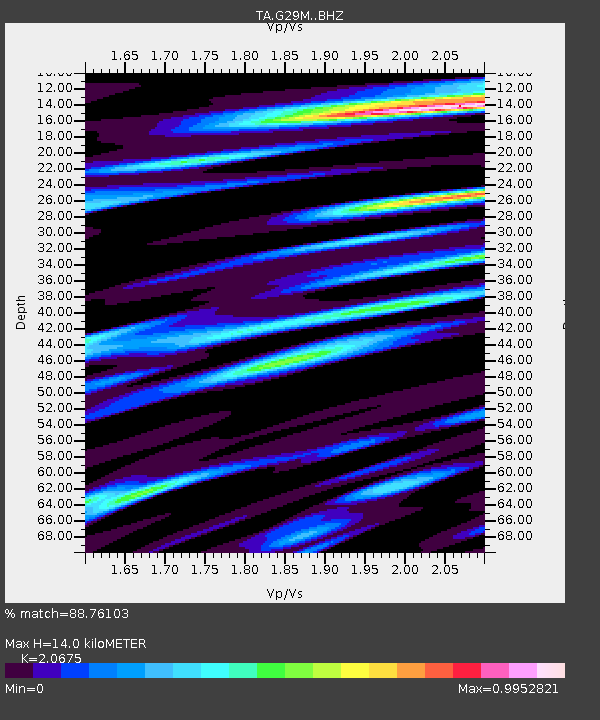
| Estimated Moho Depth: |
14.0 km |
| Estimated Crust Vp/Vs: |
2.07 |
| Assumed Crust Vp: |
6.577 km/s |
| Estimated Crust Vs: |
3.181 km/s |
| Estimated Crust Poisson's Ratio: |
0.35 |
|
| Radial Match: |
88.76103 % |
| Radial Bump: |
400 |
| Transverse Match: |
77.99137 % |
| Transverse Bump: |
400 |
| SOD ConfigId: |
21709731 |
| Insert Time: |
2020-06-27 16:14:40.458 +0000 |
| GWidth: |
2.5 |
| Max Bumps: |
400 |
| Tol: |
0.001 |
|

Signal To Noise
| Channel | StoN | STA | LTA |
| TA:G29M: :BHZ:20200613T16:01:16.524982Z | 8.509337 | 1.3153635E-6 | 1.5457884E-7 |
| TA:G29M: :BHN:20200613T16:01:16.524982Z | 0.73411644 | 1.8412902E-7 | 2.5081718E-7 |
| TA:G29M: :BHE:20200613T16:01:16.524982Z | 3.1979744 | 5.189189E-7 | 1.6226487E-7 |
| Arrivals |
| Ps | 2.4 SECOND |
| PpPs | 6.3 SECOND |
| PsPs/PpSs | 8.7 SECOND |


