You are here: Home > Network List > TA - USArray Transportable Network (new EarthScope stations) Stations List
> Station I20K Naaghedeneel ne tl'uh kk'aat, AK, USA > Earthquake Result Viewer
I20K Naaghedeneel ne tl'uh kk'aat, AK, USA - Earthquake Result Viewer
| Earthquake location: |
Ryukyu Islands, Japan |
| Earthquake latitude/longitude: |
28.9/128.3 |
| Earthquake time(UTC): |
2020/06/13 (165) 15:51:23 GMT |
| Earthquake Depth: |
160 km |
| Earthquake Magnitude: |
6.6 Mww |
| Earthquake Catalog/Contributor: |
NEIC PDE/us |
|
| Network: |
TA USArray Transportable Network (new EarthScope stations) |
| Station: |
I20K Naaghedeneel ne tl'uh kk'aat, AK, USA |
| Lat/Lon: |
64.80 N/154.48 W |
| Elevation: |
75 m |
|
| Distance: |
58.8 deg |
| Az: |
29.221 deg |
| Baz: |
272.106 deg |
| Ray Param: |
0.06209313 |
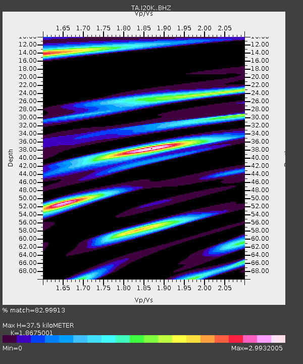
| Estimated Moho Depth: |
37.5 km |
| Estimated Crust Vp/Vs: |
1.87 |
| Assumed Crust Vp: |
6.566 km/s |
| Estimated Crust Vs: |
3.516 km/s |
| Estimated Crust Poisson's Ratio: |
0.30 |
|
| Radial Match: |
82.99913 % |
| Radial Bump: |
400 |
| Transverse Match: |
84.12824 % |
| Transverse Bump: |
400 |
| SOD ConfigId: |
21709731 |
| Insert Time: |
2020-06-27 16:14:57.937 +0000 |
| GWidth: |
2.5 |
| Max Bumps: |
400 |
| Tol: |
0.001 |
|

Signal To Noise
| Channel | StoN | STA | LTA |
| TA:I20K: :BHZ:20200613T16:00:34.274982Z | 25.910059 | 1.7519494E-6 | 6.7616575E-8 |
| TA:I20K: :BHN:20200613T16:00:34.274982Z | 1.5914608 | 2.0476593E-7 | 1.2866539E-7 |
| TA:I20K: :BHE:20200613T16:00:34.274982Z | 3.625484 | 6.931656E-7 | 1.9119257E-7 |
| Arrivals |
| Ps | 5.2 SECOND |
| PpPs | 16 SECOND |
| PsPs/PpSs | 21 SECOND |


