You are here: Home > Network List > TA - USArray Transportable Network (new EarthScope stations) Stations List
> Station J16K Anvik River, AK, USA > Earthquake Result Viewer
J16K Anvik River, AK, USA - Earthquake Result Viewer
| Earthquake location: |
Ryukyu Islands, Japan |
| Earthquake latitude/longitude: |
28.9/128.3 |
| Earthquake time(UTC): |
2020/06/13 (165) 15:51:23 GMT |
| Earthquake Depth: |
160 km |
| Earthquake Magnitude: |
6.6 Mww |
| Earthquake Catalog/Contributor: |
NEIC PDE/us |
|
| Network: |
TA USArray Transportable Network (new EarthScope stations) |
| Station: |
J16K Anvik River, AK, USA |
| Lat/Lon: |
63.28 N/160.60 W |
| Elevation: |
328 m |
|
| Distance: |
56.1 deg |
| Az: |
31.01 deg |
| Baz: |
267.568 deg |
| Ray Param: |
0.06382916 |
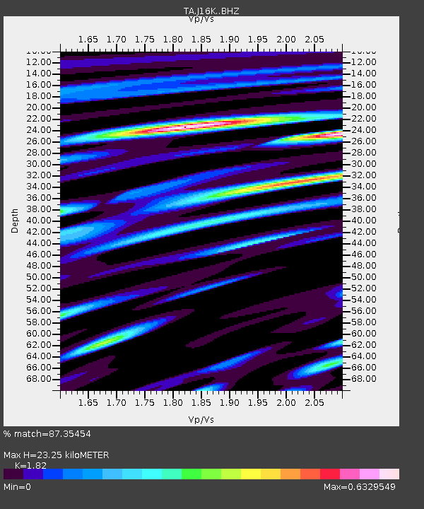
| Estimated Moho Depth: |
23.25 km |
| Estimated Crust Vp/Vs: |
1.82 |
| Assumed Crust Vp: |
6.276 km/s |
| Estimated Crust Vs: |
3.448 km/s |
| Estimated Crust Poisson's Ratio: |
0.28 |
|
| Radial Match: |
87.35454 % |
| Radial Bump: |
400 |
| Transverse Match: |
73.99013 % |
| Transverse Bump: |
400 |
| SOD ConfigId: |
21709731 |
| Insert Time: |
2020-06-27 16:15:03.791 +0000 |
| GWidth: |
2.5 |
| Max Bumps: |
400 |
| Tol: |
0.001 |
|

Signal To Noise
| Channel | StoN | STA | LTA |
| TA:J16K: :BHZ:20200613T16:00:15.44997Z | 12.697076 | 6.229788E-7 | 4.9064745E-8 |
| TA:J16K: :BHN:20200613T16:00:15.44997Z | 1.4057071 | 7.0242244E-8 | 4.996933E-8 |
| TA:J16K: :BHE:20200613T16:00:15.44997Z | 6.5827293 | 3.0219073E-7 | 4.59066E-8 |
| Arrivals |
| Ps | 3.2 SECOND |
| PpPs | 10.0 SECOND |
| PsPs/PpSs | 13 SECOND |


