You are here: Home > Network List > TA - USArray Transportable Network (new EarthScope stations) Stations List
> Station L29M Grand Valley Creek, YT, CAN > Earthquake Result Viewer
L29M Grand Valley Creek, YT, CAN - Earthquake Result Viewer
| Earthquake location: |
Ryukyu Islands, Japan |
| Earthquake latitude/longitude: |
28.9/128.3 |
| Earthquake time(UTC): |
2020/06/13 (165) 15:51:23 GMT |
| Earthquake Depth: |
160 km |
| Earthquake Magnitude: |
6.6 Mww |
| Earthquake Catalog/Contributor: |
NEIC PDE/us |
|
| Network: |
TA USArray Transportable Network (new EarthScope stations) |
| Station: |
L29M Grand Valley Creek, YT, CAN |
| Lat/Lon: |
63.11 N/138.13 W |
| Elevation: |
918 m |
|
| Distance: |
66.2 deg |
| Az: |
29.737 deg |
| Baz: |
287.035 deg |
| Ray Param: |
0.057321627 |
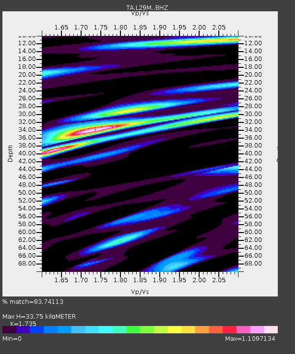
| Estimated Moho Depth: |
33.75 km |
| Estimated Crust Vp/Vs: |
1.74 |
| Assumed Crust Vp: |
6.566 km/s |
| Estimated Crust Vs: |
3.785 km/s |
| Estimated Crust Poisson's Ratio: |
0.25 |
|
| Radial Match: |
93.74113 % |
| Radial Bump: |
377 |
| Transverse Match: |
88.86935 % |
| Transverse Bump: |
400 |
| SOD ConfigId: |
21709731 |
| Insert Time: |
2020-06-27 16:15:18.495 +0000 |
| GWidth: |
2.5 |
| Max Bumps: |
400 |
| Tol: |
0.001 |
|
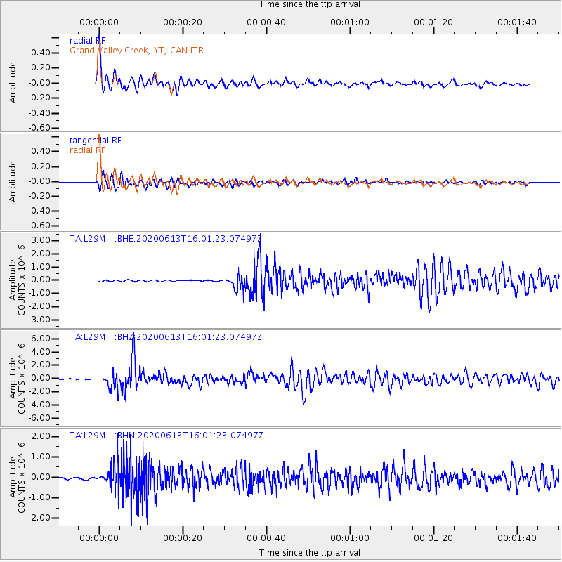
Signal To Noise
| Channel | StoN | STA | LTA |
| TA:L29M: :BHZ:20200613T16:01:23.07497Z | 24.209375 | 1.0785269E-6 | 4.454997E-8 |
| TA:L29M: :BHN:20200613T16:01:23.07497Z | 11.888433 | 5.08655E-7 | 4.2785704E-8 |
| TA:L29M: :BHE:20200613T16:01:23.07497Z | 12.036687 | 5.143354E-7 | 4.2730644E-8 |
| Arrivals |
| Ps | 3.9 SECOND |
| PpPs | 13 SECOND |
| PsPs/PpSs | 17 SECOND |


