You are here: Home > Network List > TA - USArray Transportable Network (new EarthScope stations) Stations List
> Station O29M Mount Kennedy, YT, CAN > Earthquake Result Viewer
O29M Mount Kennedy, YT, CAN - Earthquake Result Viewer
| Earthquake location: |
Ryukyu Islands, Japan |
| Earthquake latitude/longitude: |
28.9/128.3 |
| Earthquake time(UTC): |
2020/06/13 (165) 15:51:23 GMT |
| Earthquake Depth: |
160 km |
| Earthquake Magnitude: |
6.6 Mww |
| Earthquake Catalog/Contributor: |
NEIC PDE/us |
|
| Network: |
TA USArray Transportable Network (new EarthScope stations) |
| Station: |
O29M Mount Kennedy, YT, CAN |
| Lat/Lon: |
60.30 N/138.58 W |
| Elevation: |
1423 m |
|
| Distance: |
66.8 deg |
| Az: |
32.737 deg |
| Baz: |
287.838 deg |
| Ray Param: |
0.056915622 |
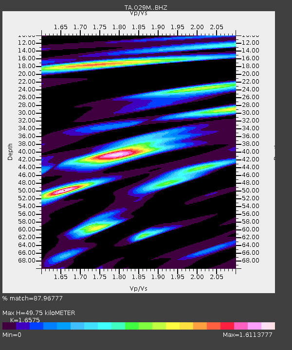
| Estimated Moho Depth: |
49.75 km |
| Estimated Crust Vp/Vs: |
1.66 |
| Assumed Crust Vp: |
6.566 km/s |
| Estimated Crust Vs: |
3.961 km/s |
| Estimated Crust Poisson's Ratio: |
0.21 |
|
| Radial Match: |
87.96777 % |
| Radial Bump: |
400 |
| Transverse Match: |
86.52951 % |
| Transverse Bump: |
400 |
| SOD ConfigId: |
21709731 |
| Insert Time: |
2020-06-27 16:15:53.174 +0000 |
| GWidth: |
2.5 |
| Max Bumps: |
400 |
| Tol: |
0.001 |
|
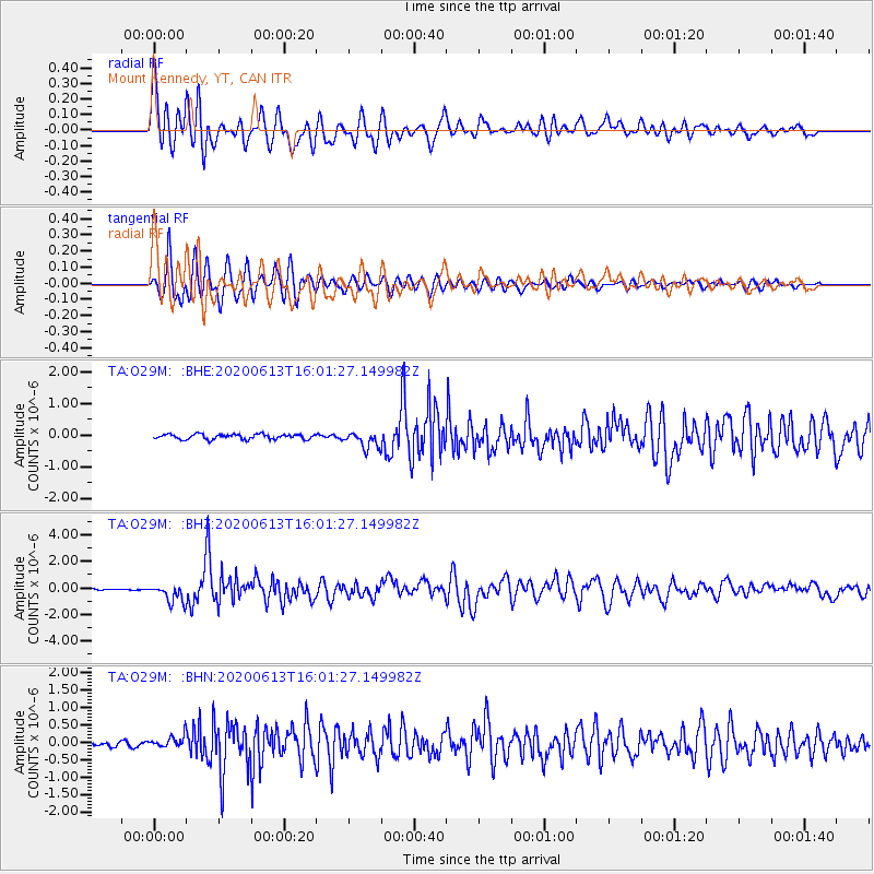
Signal To Noise
| Channel | StoN | STA | LTA |
| TA:O29M: :BHZ:20200613T16:01:27.149982Z | 9.346427 | 6.8125445E-7 | 7.288929E-8 |
| TA:O29M: :BHN:20200613T16:01:27.149982Z | 2.4338143 | 1.6850791E-7 | 6.923614E-8 |
| TA:O29M: :BHE:20200613T16:01:27.149982Z | 3.2472591 | 2.587029E-7 | 7.966807E-8 |
| Arrivals |
| Ps | 5.2 SECOND |
| PpPs | 19 SECOND |
| PsPs/PpSs | 24 SECOND |


