You are here: Home > Network List > TA - USArray Transportable Network (new EarthScope stations) Stations List
> Station O30N Mendenhall, YT, Canada > Earthquake Result Viewer
O30N Mendenhall, YT, Canada - Earthquake Result Viewer
| Earthquake location: |
Ryukyu Islands, Japan |
| Earthquake latitude/longitude: |
28.9/128.3 |
| Earthquake time(UTC): |
2020/06/13 (165) 15:51:23 GMT |
| Earthquake Depth: |
160 km |
| Earthquake Magnitude: |
6.6 Mww |
| Earthquake Catalog/Contributor: |
NEIC PDE/us |
|
| Network: |
TA USArray Transportable Network (new EarthScope stations) |
| Station: |
O30N Mendenhall, YT, Canada |
| Lat/Lon: |
60.77 N/136.09 W |
| Elevation: |
821 m |
|
| Distance: |
67.8 deg |
| Az: |
31.827 deg |
| Baz: |
289.648 deg |
| Ray Param: |
0.05624876 |
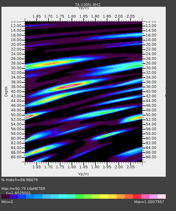
| Estimated Moho Depth: |
50.75 km |
| Estimated Crust Vp/Vs: |
1.60 |
| Assumed Crust Vp: |
6.566 km/s |
| Estimated Crust Vs: |
4.097 km/s |
| Estimated Crust Poisson's Ratio: |
0.18 |
|
| Radial Match: |
86.96679 % |
| Radial Bump: |
400 |
| Transverse Match: |
78.42293 % |
| Transverse Bump: |
400 |
| SOD ConfigId: |
21709731 |
| Insert Time: |
2020-06-27 16:15:55.794 +0000 |
| GWidth: |
2.5 |
| Max Bumps: |
400 |
| Tol: |
0.001 |
|

Signal To Noise
| Channel | StoN | STA | LTA |
| TA:O30N: :BHZ:20200613T16:01:33.500019Z | 7.5335927 | 5.701535E-7 | 7.5681484E-8 |
| TA:O30N: :BHN:20200613T16:01:33.500019Z | 2.0611348 | 9.925027E-8 | 4.815322E-8 |
| TA:O30N: :BHE:20200613T16:01:33.500019Z | 3.9205403 | 2.3762348E-7 | 6.060988E-8 |
| Arrivals |
| Ps | 4.9 SECOND |
| PpPs | 19 SECOND |
| PsPs/PpSs | 24 SECOND |


