You are here: Home > Network List > TD - TransAlta Monitoring Network Stations List
> Station TD009 Z > Earthquake Result Viewer
TD009 Z - Earthquake Result Viewer
| Earthquake location: |
Ryukyu Islands, Japan |
| Earthquake latitude/longitude: |
28.9/128.3 |
| Earthquake time(UTC): |
2020/06/13 (165) 15:51:23 GMT |
| Earthquake Depth: |
160 km |
| Earthquake Magnitude: |
6.6 Mww |
| Earthquake Catalog/Contributor: |
NEIC PDE/us |
|
| Network: |
TD TransAlta Monitoring Network |
| Station: |
TD009 Z |
| Lat/Lon: |
52.32 N/116.32 W |
| Elevation: |
1335 m |
|
| Distance: |
81.4 deg |
| Az: |
34.103 deg |
| Baz: |
306.809 deg |
| Ray Param: |
0.04721468 |
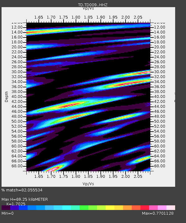
| Estimated Moho Depth: |
69.25 km |
| Estimated Crust Vp/Vs: |
1.70 |
| Assumed Crust Vp: |
6.142 km/s |
| Estimated Crust Vs: |
3.608 km/s |
| Estimated Crust Poisson's Ratio: |
0.24 |
|
| Radial Match: |
82.055534 % |
| Radial Bump: |
400 |
| Transverse Match: |
79.31839 % |
| Transverse Bump: |
400 |
| SOD ConfigId: |
21709731 |
| Insert Time: |
2020-06-27 16:16:17.748 +0000 |
| GWidth: |
2.5 |
| Max Bumps: |
400 |
| Tol: |
0.001 |
|

Signal To Noise
| Channel | StoN | STA | LTA |
| TD:TD009: :HHZ:20200613T16:02:51.380024Z | 6.3720675 | 6.9366354E-7 | 1.0886004E-7 |
| TD:TD009: :HH1:20200613T16:02:51.380024Z | 1.5859126 | 1.9009585E-7 | 1.1986528E-7 |
| TD:TD009: :HH2:20200613T16:02:51.380024Z | 2.5283666 | 2.548504E-7 | 1.0079645E-7 |
| Arrivals |
| Ps | 8.1 SECOND |
| PpPs | 30 SECOND |
| PsPs/PpSs | 38 SECOND |


