You are here: Home > Network List > UO - University of Oregon Regional Network Stations List
> Station NATH Oakridge, OR, USA > Earthquake Result Viewer
NATH Oakridge, OR, USA - Earthquake Result Viewer
| Earthquake location: |
Ryukyu Islands, Japan |
| Earthquake latitude/longitude: |
28.9/128.3 |
| Earthquake time(UTC): |
2020/06/13 (165) 15:51:23 GMT |
| Earthquake Depth: |
160 km |
| Earthquake Magnitude: |
6.6 Mww |
| Earthquake Catalog/Contributor: |
NEIC PDE/us |
|
| Network: |
UO University of Oregon Regional Network |
| Station: |
NATH Oakridge, OR, USA |
| Lat/Lon: |
43.79 N/122.41 W |
| Elevation: |
729 m |
|
| Distance: |
83.0 deg |
| Az: |
43.51 deg |
| Baz: |
303.557 deg |
| Ray Param: |
0.0461273 |
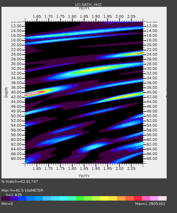
| Estimated Moho Depth: |
40.5 km |
| Estimated Crust Vp/Vs: |
1.62 |
| Assumed Crust Vp: |
6.522 km/s |
| Estimated Crust Vs: |
4.013 km/s |
| Estimated Crust Poisson's Ratio: |
0.20 |
|
| Radial Match: |
82.61747 % |
| Radial Bump: |
399 |
| Transverse Match: |
78.29213 % |
| Transverse Bump: |
400 |
| SOD ConfigId: |
21709731 |
| Insert Time: |
2020-06-27 16:17:07.127 +0000 |
| GWidth: |
2.5 |
| Max Bumps: |
400 |
| Tol: |
0.001 |
|

Signal To Noise
| Channel | StoN | STA | LTA |
| UO:NATH: :HHZ:20200613T16:02:59.527973Z | 8.613494 | 6.145082E-7 | 7.13425E-8 |
| UO:NATH: :HHN:20200613T16:02:59.527973Z | 1.7827523 | 1.5655037E-7 | 8.7813866E-8 |
| UO:NATH: :HHE:20200613T16:02:59.527973Z | 3.6454728 | 2.5310132E-7 | 6.9428935E-8 |
| Arrivals |
| Ps | 4.0 SECOND |
| PpPs | 16 SECOND |
| PsPs/PpSs | 20 SECOND |


