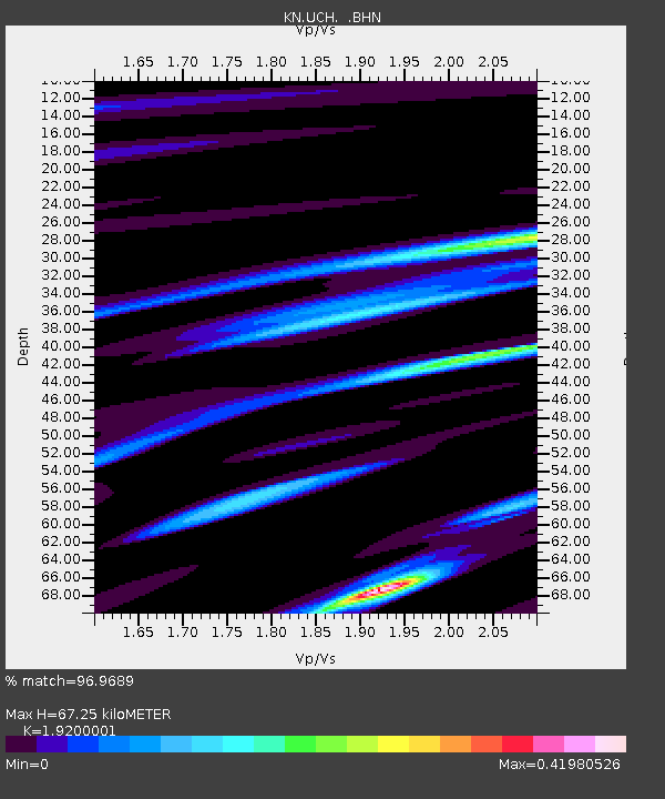
UCH KN.UCH - Earthquake Result Viewer
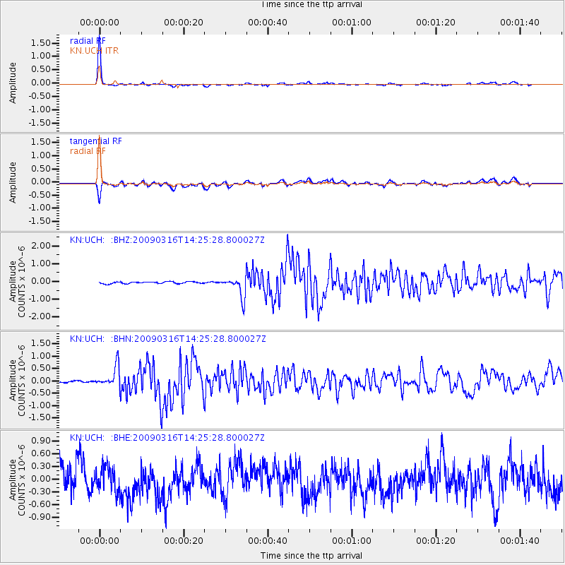
Earthquake location: Talaud Islands, Indonesia
Earthquake latitude/longitude: 3.8/126.6
Earthquake time(UTC): 2009/03/16 (075) 14:15:56 GMT
Earthquake Depth: 35 km
Earthquake Magnitude: 6.2 MB, 6.0 MS, 6.3 MW, 6.3 MW
Earthquake Catalog/Contributor: WHDF/NEIC
Network: KN Kyrgyz Seismic Telemetry Network
Station: UCH KN.UCH
Lat/Lon: 42.23 N/74.51 E
Elevation: 3850 m
Distance: 60.0 deg
Az: 317.453 deg
Baz: 114.71 deg
Ray Param: 0.06176031
Estimated Moho Depth: 67.25 km
Estimated Crust Vp/Vs: 1.92
Assumed Crust Vp: 6.306 km/s
Estimated Crust Vs: 3.284 km/s
Estimated Crust Poisson's Ratio: 0.31
Radial Match: 96.9689 %
Radial Bump: 192
Transverse Match: 68.67194 %
Transverse Bump: 400
SOD ConfigId: 2658
Insert Time: 2010-03-08 21:17:35.577 +0000
GWidth: 2.5
Max Bumps: 400
Tol: 0.001

Signal To Noise

ChannelStoNSTALTA
KN:UCH: :BHN:20090316T14:25:28.800027Z11.108764.2150177E-73.7943188E-8
KN:UCH: :BHE:20090316T14:25:28.800027Z0.809392752.9416856E-73.6344355E-7
KN:UCH: :BHZ:20090316T14:25:28.800027Z11.8260325.955637E-75.03604E-8
Arrivals
Ps10 SECOND
PpPs30 SECOND
PsPs/PpSs40 SECOND