You are here: Home > Network List > KN - Kyrgyz Seismic Telemetry Network Stations List
> Station UCH KN.UCH > Earthquake Result Viewer
UCH KN.UCH - Earthquake Result Viewer

| Earthquake location: |
Mindanao, Philippines |
| Earthquake latitude/longitude: |
5.8/125.4 |
| Earthquake time(UTC): |
2008/12/25 (360) 03:20:29 GMT |
| Earthquake Depth: |
211 km |
| Earthquake Magnitude: |
6.1 MB, 6.3 MW, 6.3 MW |
| Earthquake Catalog/Contributor: |
WHDF/NEIC |
|
| Network: |
KN Kyrgyz Seismic Telemetry Network |
| Station: |
UCH KN.UCH |
| Lat/Lon: |
42.23 N/74.51 E |
| Elevation: |
3850 m |
|
| Distance: |
57.8 deg |
| Az: |
317.085 deg |
| Baz: |
114.185 deg |
| Ray Param: |
0.06257442 |
| Estimated Moho Depth: |
69.75 km |
| Estimated Crust Vp/Vs: |
1.78 |
| Assumed Crust Vp: |
6.306 km/s |
| Estimated Crust Vs: |
3.538 km/s |
| Estimated Crust Poisson's Ratio: |
0.27 |
|
| Radial Match: |
98.14381 % |
| Radial Bump: |
140 |
| Transverse Match: |
75.60943 % |
| Transverse Bump: |
400 |
| SOD ConfigId: |
2658 |
| Insert Time: |
2010-03-08 21:17:39.318 +0000 |
| GWidth: |
2.5 |
| Max Bumps: |
400 |
| Tol: |
0.001 |
|
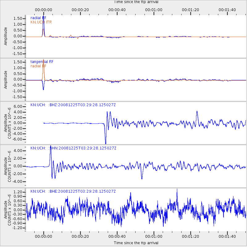
Signal To Noise
| Channel | StoN | STA | LTA |
| KN:UCH: :BHN:20081225T03:29:28.125027Z | 34.500355 | 1.8123967E-6 | 5.2532698E-8 |
| KN:UCH: :BHE:20081225T03:29:28.125027Z | 0.6651561 | 2.877422E-7 | 4.3259348E-7 |
| KN:UCH: :BHZ:20081225T03:29:28.125027Z | 36.52052 | 2.5655104E-6 | 7.024847E-8 |
| Arrivals |
| Ps | 9.1 SECOND |
| PpPs | 29 SECOND |
| PsPs/PpSs | 38 SECOND |


