You are here: Home > Network List > US - United States National Seismic Network Stations List
> Station DGMT Dagmar, Montana, USA > Earthquake Result Viewer
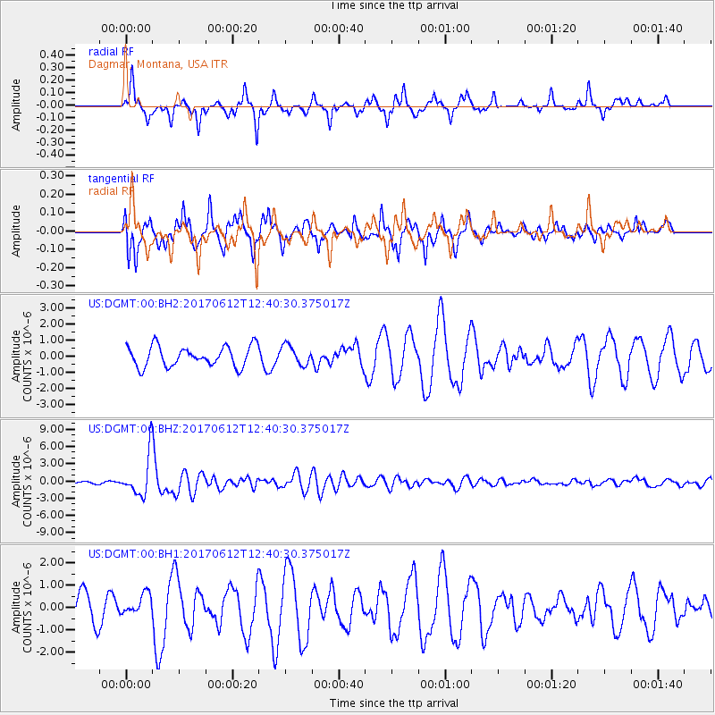
DGMT Dagmar, Montana, USA - Earthquake Result Viewer
*The percent match for this event was below the threshold and hence no stack was calculated.
| Earthquake location: |
Aegean Sea |
| Earthquake latitude/longitude: |
38.9/26.4 |
| Earthquake time(UTC): |
2017/06/12 (163) 12:28:38 GMT |
| Earthquake Depth: |
10 km |
| Earthquake Magnitude: |
6.3 Mww |
| Earthquake Catalog/Contributor: |
NEIC PDE/us |
|
| Network: |
US United States National Seismic Network |
| Station: |
DGMT Dagmar, Montana, USA |
| Lat/Lon: |
48.47 N/104.20 W |
| Elevation: |
0.0 m |
|
| Distance: |
82.6 deg |
| Az: |
329.342 deg |
| Baz: |
36.698 deg |
| Ray Param: |
$rayparam |
*The percent match for this event was below the threshold and hence was not used in the summary stack. |
|
| Radial Match: |
88.31987 % |
| Radial Bump: |
302 |
| Transverse Match: |
72.5465 % |
| Transverse Bump: |
391 |
| SOD ConfigId: |
2140511 |
| Insert Time: |
2017-06-26 04:25:52.472 +0000 |
| GWidth: |
2.5 |
| Max Bumps: |
400 |
| Tol: |
0.001 |
|
Signal To Noise
| Channel | StoN | STA | LTA |
| US:DGMT:00:BHZ:20170612T12:40:30.375017Z | 19.476252 | 3.5644807E-6 | 1.8301678E-7 |
| US:DGMT:00:BH1:20170612T12:40:30.375017Z | 0.7402956 | 4.774117E-7 | 6.4489336E-7 |
| US:DGMT:00:BH2:20170612T12:40:30.375017Z | 0.94889927 | 6.033384E-7 | 6.3582974E-7 |
| Arrivals |
| Ps | |
| PpPs | |
| PsPs/PpSs | |


