You are here: Home > Network List > KN - Kyrgyz Seismic Telemetry Network Stations List
> Station UCH KN.UCH > Earthquake Result Viewer
UCH KN.UCH - Earthquake Result Viewer
| Earthquake location: |
Northern Sumatra, Indonesia |
| Earthquake latitude/longitude: |
5.1/94.8 |
| Earthquake time(UTC): |
2006/09/16 (259) 06:17:46 GMT |
| Earthquake Depth: |
49 km |
| Earthquake Magnitude: |
5.6 MB, 4.9 MS, 5.2 MW |
| Earthquake Catalog/Contributor: |
WHDF/NEIC |
|
| Network: |
KN Kyrgyz Seismic Telemetry Network |
| Station: |
UCH KN.UCH |
| Lat/Lon: |
42.23 N/74.51 E |
| Elevation: |
3850 m |
|
| Distance: |
41.1 deg |
| Az: |
336.969 deg |
| Baz: |
148.353 deg |
| Ray Param: |
0.07386265 |
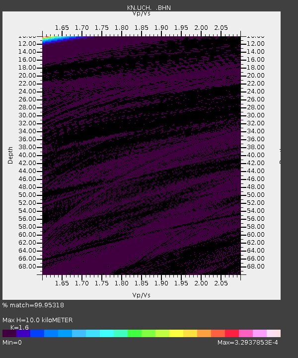
| Estimated Moho Depth: |
10.0 km |
| Estimated Crust Vp/Vs: |
1.60 |
| Assumed Crust Vp: |
6.306 km/s |
| Estimated Crust Vs: |
3.941 km/s |
| Estimated Crust Poisson's Ratio: |
0.18 |
|
| Radial Match: |
99.95318 % |
| Radial Bump: |
4 |
| Transverse Match: |
99.99305 % |
| Transverse Bump: |
2 |
| SOD ConfigId: |
2665 |
| Insert Time: |
2010-03-08 21:18:03.288 +0000 |
| GWidth: |
2.5 |
| Max Bumps: |
400 |
| Tol: |
0.001 |
|
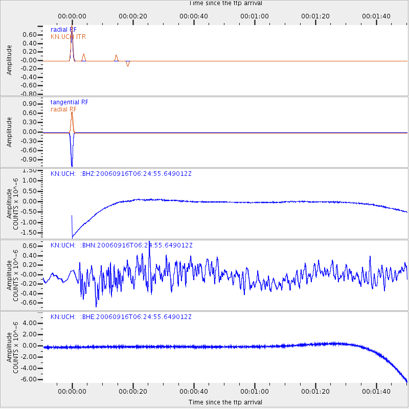
Signal To Noise
| Channel | StoN | STA | LTA |
| KN:UCH: :BHN:20060916T06:24:55.649012Z | 2.1209645 | 2.0830305E-7 | 9.821147E-8 |
| KN:UCH: :BHE:20060916T06:24:55.649012Z | 0.9015128 | 4.5911406E-7 | 5.092707E-7 |
| KN:UCH: :BHZ:20060916T06:24:55.649012Z | 0.90349054 | 4.8320015E-7 | 5.3481483E-7 |
| Arrivals |
| Ps | 1.0 SECOND |
| PpPs | 3.8 SECOND |
| PsPs/PpSs | 4.9 SECOND |


