You are here: Home > Network List > KN - Kyrgyz Seismic Telemetry Network Stations List
> Station UCH KN.UCH > Earthquake Result Viewer
UCH KN.UCH - Earthquake Result Viewer
| Earthquake location: |
Northern Sumatra, Indonesia |
| Earthquake latitude/longitude: |
1.5/97.2 |
| Earthquake time(UTC): |
2006/07/30 (211) 01:28:14 GMT |
| Earthquake Depth: |
30 km |
| Earthquake Magnitude: |
5.1 MB, 5.6 MW, 5.6 MW |
| Earthquake Catalog/Contributor: |
WHDF/NEIC |
|
| Network: |
KN Kyrgyz Seismic Telemetry Network |
| Station: |
UCH KN.UCH |
| Lat/Lon: |
42.23 N/74.51 E |
| Elevation: |
3850 m |
|
| Distance: |
45.4 deg |
| Az: |
336.297 deg |
| Baz: |
147.244 deg |
| Ray Param: |
0.0712425 |
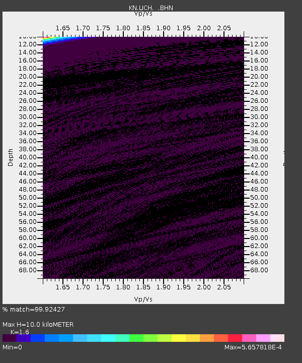
| Estimated Moho Depth: |
10.0 km |
| Estimated Crust Vp/Vs: |
1.60 |
| Assumed Crust Vp: |
6.306 km/s |
| Estimated Crust Vs: |
3.941 km/s |
| Estimated Crust Poisson's Ratio: |
0.18 |
|
| Radial Match: |
99.92427 % |
| Radial Bump: |
6 |
| Transverse Match: |
99.89312 % |
| Transverse Bump: |
9 |
| SOD ConfigId: |
2665 |
| Insert Time: |
2010-03-08 21:18:05.676 +0000 |
| GWidth: |
2.5 |
| Max Bumps: |
400 |
| Tol: |
0.001 |
|
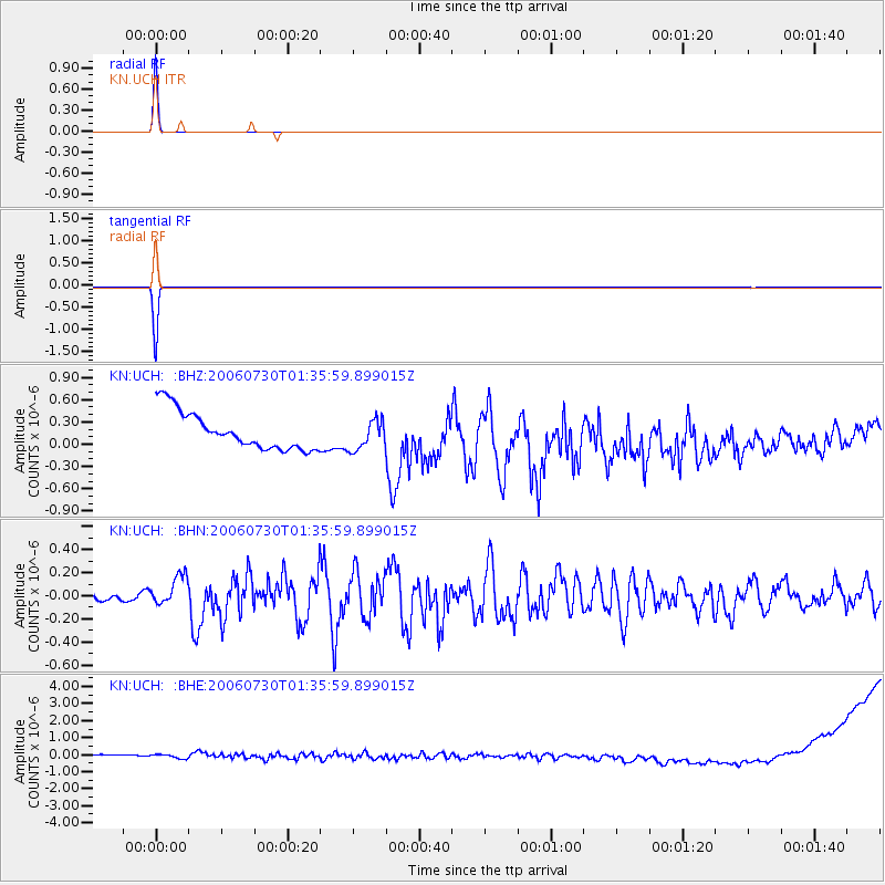
Signal To Noise
| Channel | StoN | STA | LTA |
| KN:UCH: :BHN:20060730T01:35:59.899015Z | 3.3817925 | 1.2919631E-7 | 3.82035E-8 |
| KN:UCH: :BHE:20060730T01:35:59.899015Z | 0.79003423 | 2.9056702E-7 | 3.677904E-7 |
| KN:UCH: :BHZ:20060730T01:35:59.899015Z | 0.79506516 | 2.0244885E-7 | 2.5463174E-7 |
| Arrivals |
| Ps | 1.0 SECOND |
| PpPs | 3.9 SECOND |
| PsPs/PpSs | 4.9 SECOND |


