UCH KN.UCH - Earthquake Result Viewer
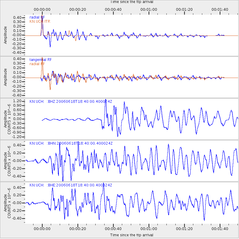
Earthquake location: Northern Mid-Atlantic Ridge
Earthquake latitude/longitude: 33.0/-39.7
Earthquake time(UTC): 2006/06/18 (169) 18:28:02 GMT
Earthquake Depth: 10 km
Earthquake Magnitude: 5.5 MB, 5.8 MS, 5.9 MW, 5.9 MW
Earthquake Catalog/Contributor: WHDF/NEIC
Network: KN Kyrgyz Seismic Telemetry Network
Station: UCH KN.UCH
Lat/Lon: 42.23 N/74.51 E
Elevation: 3850 m
Distance: 83.8 deg
Az: 42.946 deg
Baz: 309.592 deg
Ray Param: 0.04590243
Estimated Moho Depth: 44.25 km
Estimated Crust Vp/Vs: 1.91
Assumed Crust Vp: 6.306 km/s
Estimated Crust Vs: 3.302 km/s
Estimated Crust Poisson's Ratio: 0.31
Radial Match: 94.08838 %
Radial Bump: 327
Transverse Match: 85.69424 %
Transverse Bump: 400
SOD ConfigId: 2665
Insert Time: 2010-03-08 21:18:16.063 +0000
GWidth: 2.5
Max Bumps: 400
Tol: 0.001

Signal To Noise

ChannelStoNSTALTA
KN:UCH: :BHN:20060618T18:40:00.400024Z1.68023555.403171E-83.2157224E-8
KN:UCH: :BHE:20060618T18:40:00.400024Z2.5992557.1044454E-82.7332621E-8
KN:UCH: :BHZ:20060618T18:40:00.400024Z6.55576852.5038722E-73.819342E-8
Arrivals
Ps6.5 SECOND
PpPs20 SECOND
PsPs/PpSs26 SECOND