You are here: Home > Network List > TS - TERRAscope (Southern California Seismic Network) Stations List
> Station VTV Victorville, California, USA > Earthquake Result Viewer
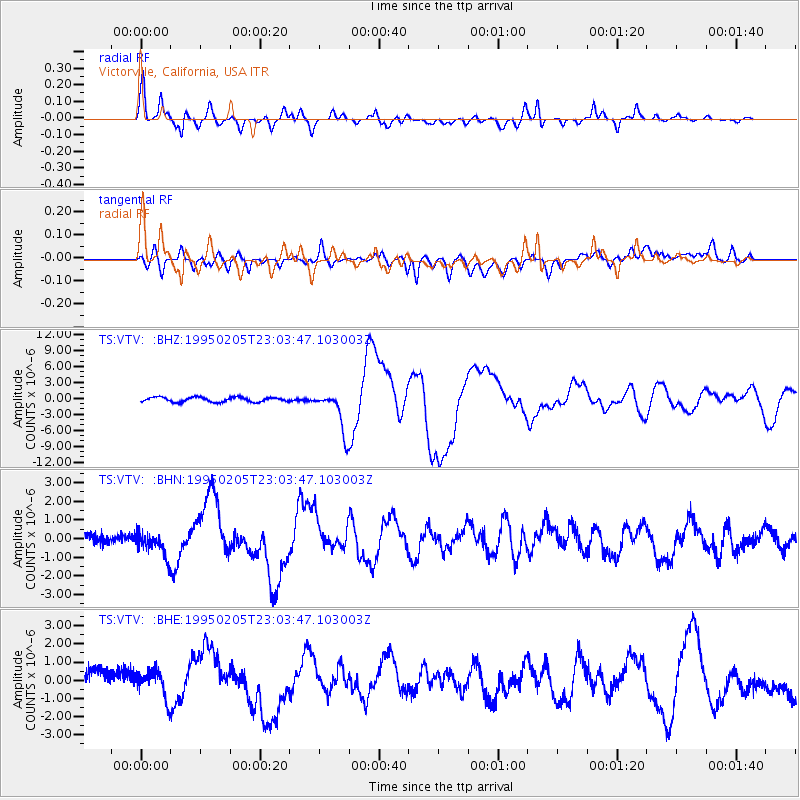
VTV Victorville, California, USA - Earthquake Result Viewer

| Earthquake location: |
Off E. Coast Of N. Island, N.Z. |
| Earthquake latitude/longitude: |
-37.7/178.8 |
| Earthquake time(UTC): |
1995/02/05 (036) 22:51:10 GMT |
| Earthquake Depth: |
59 km |
| Earthquake Magnitude: |
6.4 MB, 7.1 UNKNOWN, 7.1 MW |
| Earthquake Catalog/Contributor: |
WHDF/NEIC |
|
| Network: |
TS TERRAscope (Southern California Seismic Network) |
| Station: |
VTV Victorville, California, USA |
| Lat/Lon: |
34.57 N/117.33 W |
| Elevation: |
847 m |
|
| Distance: |
93.2 deg |
| Az: |
47.923 deg |
| Baz: |
225.504 deg |
| Ray Param: |
0.041277524 |
| Estimated Moho Depth: |
67.25 km |
| Estimated Crust Vp/Vs: |
2.06 |
| Assumed Crust Vp: |
6.276 km/s |
| Estimated Crust Vs: |
3.047 km/s |
| Estimated Crust Poisson's Ratio: |
0.35 |
|
| Radial Match: |
86.068306 % |
| Radial Bump: |
400 |
| Transverse Match: |
50.568886 % |
| Transverse Bump: |
400 |
| SOD ConfigId: |
6273 |
| Insert Time: |
2010-02-26 14:54:04.892 +0000 |
| GWidth: |
2.5 |
| Max Bumps: |
400 |
| Tol: |
0.001 |
|
Signal To Noise
| Channel | StoN | STA | LTA |
| TS:VTV: :BHN:19950205T23:03:47.103003Z | 2.003638 | 7.222123E-7 | 3.6045049E-7 |
| TS:VTV: :BHE:19950205T23:03:47.103003Z | 0.80937994 | 8.743323E-7 | 1.0802495E-6 |
| TS:VTV: :BHZ:19950205T23:03:47.103003Z | 8.756333 | 3.883011E-6 | 4.434517E-7 |
| Arrivals |
| Ps | 12 SECOND |
| PpPs | 32 SECOND |
| PsPs/PpSs | 44 SECOND |


