You are here: Home > Network List > US - United States National Seismic Network Stations List
> Station MNTX Cornudas Mountains, Texas, USA > Earthquake Result Viewer
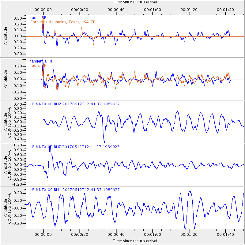
MNTX Cornudas Mountains, Texas, USA - Earthquake Result Viewer
*The percent match for this event was below the threshold and hence no stack was calculated.
| Earthquake location: |
Aegean Sea |
| Earthquake latitude/longitude: |
38.9/26.4 |
| Earthquake time(UTC): |
2017/06/12 (163) 12:28:38 GMT |
| Earthquake Depth: |
10 km |
| Earthquake Magnitude: |
6.3 Mww |
| Earthquake Catalog/Contributor: |
NEIC PDE/us |
|
| Network: |
US United States National Seismic Network |
| Station: |
MNTX Cornudas Mountains, Texas, USA |
| Lat/Lon: |
31.70 N/105.38 W |
| Elevation: |
404 m |
|
| Distance: |
96.6 deg |
| Az: |
320.189 deg |
| Baz: |
35.862 deg |
| Ray Param: |
$rayparam |
*The percent match for this event was below the threshold and hence was not used in the summary stack. |
|
| Radial Match: |
59.904877 % |
| Radial Bump: |
315 |
| Transverse Match: |
60.949448 % |
| Transverse Bump: |
351 |
| SOD ConfigId: |
2140511 |
| Insert Time: |
2017-06-26 04:26:28.589 +0000 |
| GWidth: |
2.5 |
| Max Bumps: |
400 |
| Tol: |
0.001 |
|
Signal To Noise
| Channel | StoN | STA | LTA |
| US:MNTX:00:BHZ:20170612T12:41:37.198992Z | 6.6075196 | 5.9848963E-7 | 9.0577046E-8 |
| US:MNTX:00:BH1:20170612T12:41:37.198992Z | 1.3828486 | 1.11356194E-7 | 8.052667E-8 |
| US:MNTX:00:BH2:20170612T12:41:37.198992Z | 2.7931728 | 2.1854083E-7 | 7.824107E-8 |
| Arrivals |
| Ps | |
| PpPs | |
| PsPs/PpSs | |


