You are here: Home > Network List > KN - Kyrgyz Seismic Telemetry Network Stations List
> Station UCH KN.UCH > Earthquake Result Viewer
UCH KN.UCH - Earthquake Result Viewer

| Earthquake location: |
Southern Sumatra, Indonesia |
| Earthquake latitude/longitude: |
-4.1/102.4 |
| Earthquake time(UTC): |
2000/07/22 (204) 20:56:12 GMT |
| Earthquake Depth: |
69 km |
| Earthquake Magnitude: |
5.8 MB, 5.8 MW, 5.7 MW |
| Earthquake Catalog/Contributor: |
WHDF/NEIC |
|
| Network: |
KN Kyrgyz Seismic Telemetry Network |
| Station: |
UCH KN.UCH |
| Lat/Lon: |
42.23 N/74.51 E |
| Elevation: |
3850 m |
|
| Distance: |
52.6 deg |
| Az: |
334.085 deg |
| Baz: |
144.058 deg |
| Ray Param: |
0.06648136 |
| Estimated Moho Depth: |
67.5 km |
| Estimated Crust Vp/Vs: |
1.60 |
| Assumed Crust Vp: |
6.306 km/s |
| Estimated Crust Vs: |
3.941 km/s |
| Estimated Crust Poisson's Ratio: |
0.18 |
|
| Radial Match: |
98.8584 % |
| Radial Bump: |
114 |
| Transverse Match: |
99.54746 % |
| Transverse Bump: |
83 |
| SOD ConfigId: |
3753 |
| Insert Time: |
2010-03-08 21:19:35.081 +0000 |
| GWidth: |
2.5 |
| Max Bumps: |
400 |
| Tol: |
0.001 |
|
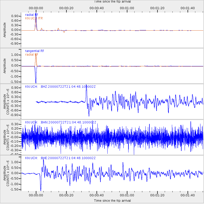
Signal To Noise
| Channel | StoN | STA | LTA |
| KN:UCH: :BHN:20000722T21:04:48.100002Z | 1.2093775 | 1.2509169E-7 | 1.0343477E-7 |
| KN:UCH: :BHE:20000722T21:04:48.100002Z | 19.375755 | 5.4078225E-7 | 2.7910252E-8 |
| KN:UCH: :BHZ:20000722T21:04:48.100002Z | 17.798853 | 3.8522813E-7 | 2.1643427E-8 |
| Arrivals |
| Ps | 6.8 SECOND |
| PpPs | 26 SECOND |
| PsPs/PpSs | 33 SECOND |


