You are here: Home > Network List > TA - USArray Transportable Network (new EarthScope stations) Stations List
> Station R33M Jennings River, BC, CAN > Earthquake Result Viewer
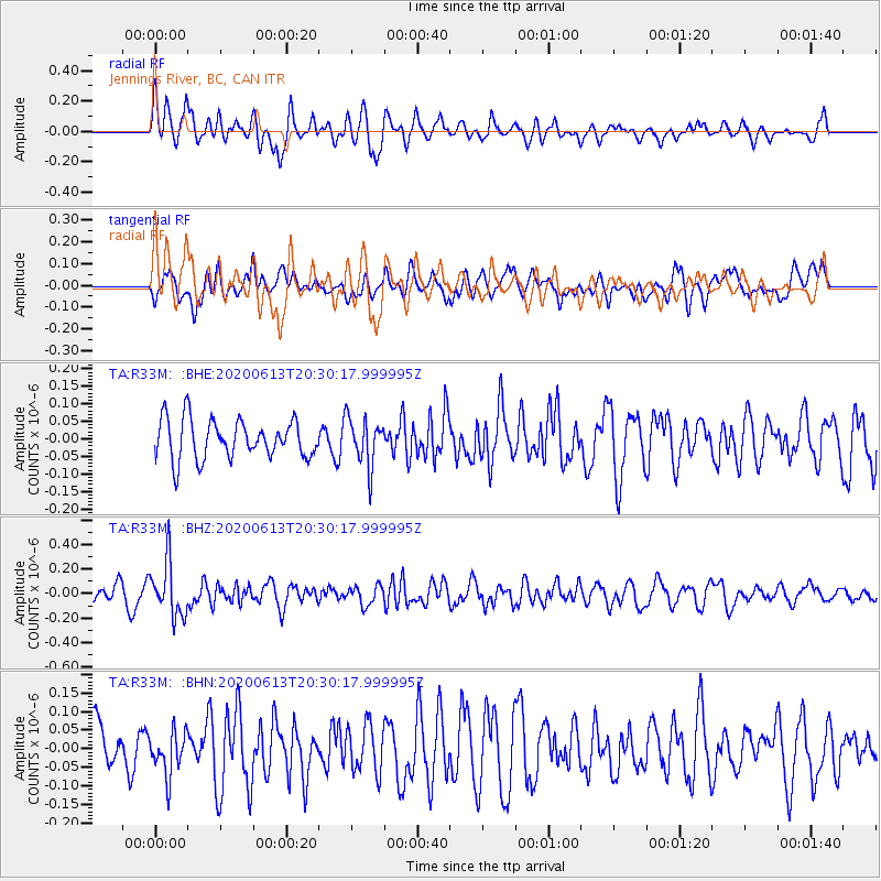
R33M Jennings River, BC, CAN - Earthquake Result Viewer
*The percent match for this event was below the threshold and hence no stack was calculated.
| Earthquake location: |
Taiwan Region |
| Earthquake latitude/longitude: |
24.3/122.5 |
| Earthquake time(UTC): |
2020/06/13 (165) 20:18:59 GMT |
| Earthquake Depth: |
54 km |
| Earthquake Magnitude: |
5.4 Mww |
| Earthquake Catalog/Contributor: |
NEIC PDE/us |
|
| Network: |
TA USArray Transportable Network (new EarthScope stations) |
| Station: |
R33M Jennings River, BC, CAN |
| Lat/Lon: |
59.39 N/130.97 W |
| Elevation: |
1437 m |
|
| Distance: |
77.4 deg |
| Az: |
30.171 deg |
| Baz: |
296.336 deg |
| Ray Param: |
$rayparam |
*The percent match for this event was below the threshold and hence was not used in the summary stack. |
|
| Radial Match: |
73.66597 % |
| Radial Bump: |
400 |
| Transverse Match: |
43.819256 % |
| Transverse Bump: |
400 |
| SOD ConfigId: |
21709731 |
| Insert Time: |
2020-06-27 20:35:42.760 +0000 |
| GWidth: |
2.5 |
| Max Bumps: |
400 |
| Tol: |
0.001 |
|
Signal To Noise
| Channel | StoN | STA | LTA |
| TA:R33M: :BHZ:20200613T20:30:17.999995Z | 2.8622 | 2.2066479E-7 | 7.709622E-8 |
| TA:R33M: :BHN:20200613T20:30:17.999995Z | 0.8073656 | 5.857633E-8 | 7.2552425E-8 |
| TA:R33M: :BHE:20200613T20:30:17.999995Z | 1.2266188 | 6.844665E-8 | 5.580108E-8 |
| Arrivals |
| Ps | |
| PpPs | |
| PsPs/PpSs | |


