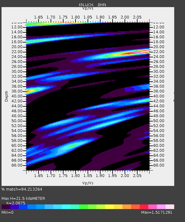
UCH KN.UCH - Earthquake Result Viewer
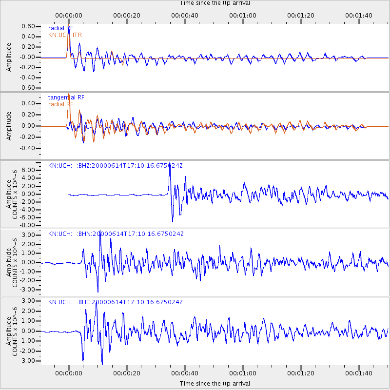
Earthquake location: Talaud Islands, Indonesia
Earthquake latitude/longitude: 4.5/127.7
Earthquake time(UTC): 2000/06/14 (166) 17:00:48 GMT
Earthquake Depth: 90 km
Earthquake Magnitude: 6.1 MB, 5.6 MS, 6.4 MW, 6.3 MW
Earthquake Catalog/Contributor: WHDF/NEIC
Network: KN Kyrgyz Seismic Telemetry Network
Station: UCH KN.UCH
Lat/Lon: 42.23 N/74.51 E
Elevation: 3850 m
Distance: 60.3 deg
Az: 316.761 deg
Baz: 113.151 deg
Ray Param: 0.06140199
Estimated Moho Depth: 21.5 km
Estimated Crust Vp/Vs: 2.10
Assumed Crust Vp: 6.306 km/s
Estimated Crust Vs: 3.006 km/s
Estimated Crust Poisson's Ratio: 0.35
Radial Match: 94.213264 %
Radial Bump: 389
Transverse Match: 90.96919 %
Transverse Bump: 400
SOD ConfigId: 3744
Insert Time: 2010-03-08 21:20:02.171 +0000
GWidth: 2.5
Max Bumps: 400
Tol: 0.001

Signal To Noise

ChannelStoNSTALTA
KN:UCH: :BHN:20000614T17:10:16.675024Z3.3014612.4054944E-77.286151E-8
KN:UCH: :BHE:20000614T17:10:16.675024Z13.2582276.0146044E-74.536507E-8
KN:UCH: :BHZ:20000614T17:10:16.675024Z18.1539021.7306103E-69.532994E-8
Arrivals
Ps3.9 SECOND
PpPs10 SECOND
PsPs/PpSs14 SECOND