You are here: Home > Network List > UW - Pacific Northwest Regional Seismic Network Stations List
> Station UMAT Pilot Rock, OR, USA > Earthquake Result Viewer
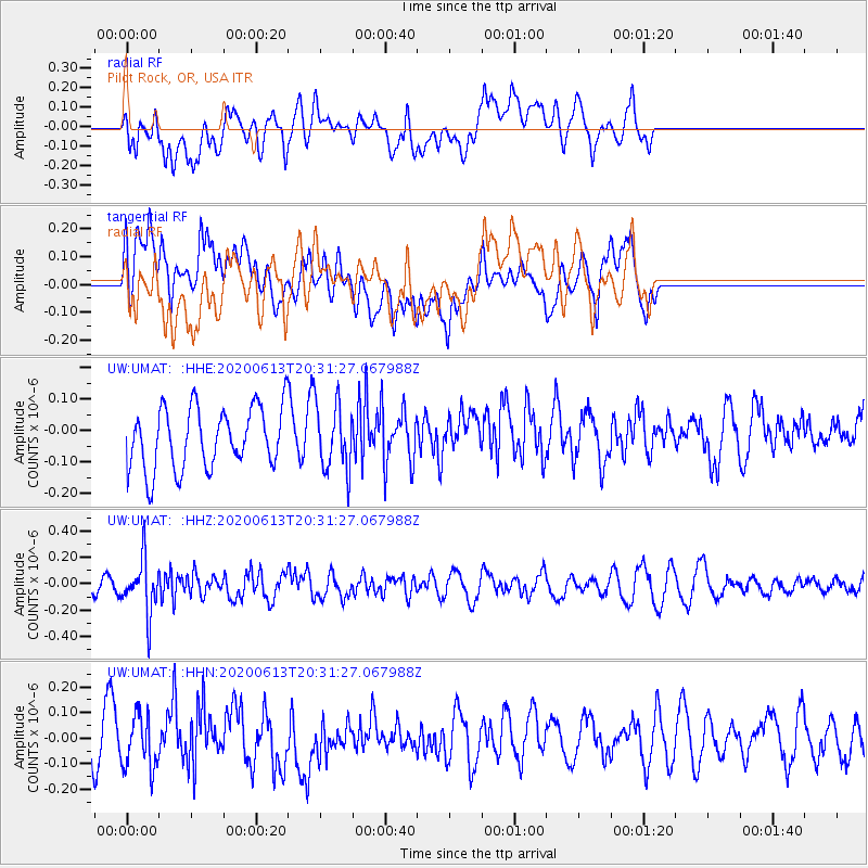
UMAT Pilot Rock, OR, USA - Earthquake Result Viewer
*The percent match for this event was below the threshold and hence no stack was calculated.
| Earthquake location: |
Taiwan Region |
| Earthquake latitude/longitude: |
24.3/122.5 |
| Earthquake time(UTC): |
2020/06/13 (165) 20:18:59 GMT |
| Earthquake Depth: |
54 km |
| Earthquake Magnitude: |
5.4 Mww |
| Earthquake Catalog/Contributor: |
NEIC PDE/us |
|
| Network: |
UW Pacific Northwest Regional Seismic Network |
| Station: |
UMAT Pilot Rock, OR, USA |
| Lat/Lon: |
45.29 N/118.96 W |
| Elevation: |
1318 m |
|
| Distance: |
91.0 deg |
| Az: |
38.319 deg |
| Baz: |
306.734 deg |
| Ray Param: |
$rayparam |
*The percent match for this event was below the threshold and hence was not used in the summary stack. |
|
| Radial Match: |
59.412823 % |
| Radial Bump: |
400 |
| Transverse Match: |
34.510475 % |
| Transverse Bump: |
400 |
| SOD ConfigId: |
21709731 |
| Insert Time: |
2020-06-27 20:38:10.636 +0000 |
| GWidth: |
2.5 |
| Max Bumps: |
400 |
| Tol: |
0.001 |
|
Signal To Noise
| Channel | StoN | STA | LTA |
| UW:UMAT: :HHZ:20200613T20:31:27.067988Z | 3.084827 | 2.0441014E-7 | 6.6263084E-8 |
| UW:UMAT: :HHN:20200613T20:31:27.067988Z | 1.258866 | 1.0260662E-7 | 8.150719E-8 |
| UW:UMAT: :HHE:20200613T20:31:27.067988Z | 1.0912478 | 1.050501E-7 | 9.626603E-8 |
| Arrivals |
| Ps | |
| PpPs | |
| PsPs/PpSs | |


