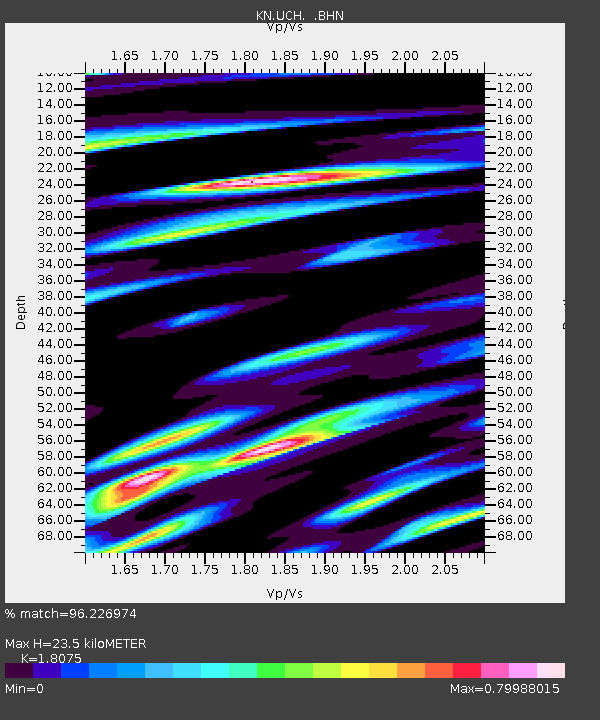
UCH KN.UCH - Earthquake Result Viewer

Earthquake location: Southeast Of Shikoku, Japan
Earthquake latitude/longitude: 29.4/132.1
Earthquake time(UTC): 2000/06/15 (167) 11:10:46 GMT
Earthquake Depth: 10 km
Earthquake Magnitude: 6.0 MB, 5.6 MS, 6.1 MW, 6.1 MW
Earthquake Catalog/Contributor: WHDF/NEIC
Network: KN Kyrgyz Seismic Telemetry Network
Station: UCH KN.UCH
Lat/Lon: 42.23 N/74.51 E
Elevation: 3850 m
Distance: 47.6 deg
Az: 301.896 deg
Baz: 86.2 deg
Ray Param: 0.069889344
Estimated Moho Depth: 23.5 km
Estimated Crust Vp/Vs: 1.81
Assumed Crust Vp: 6.306 km/s
Estimated Crust Vs: 3.489 km/s
Estimated Crust Poisson's Ratio: 0.28
Radial Match: 96.226974 %
Radial Bump: 400
Transverse Match: 91.988235 %
Transverse Bump: 400
SOD ConfigId: 3744
Insert Time: 2010-03-08 21:20:20.712 +0000
GWidth: 2.5
Max Bumps: 400
Tol: 0.001

Signal To Noise

ChannelStoNSTALTA
KN:UCH: :BHN:20000615T11:18:51.125009Z0.690100133.1419944E-84.5529543E-8
KN:UCH: :BHE:20000615T11:18:51.125009Z0.71004593.353278E-84.7226212E-8
KN:UCH: :BHZ:20000615T11:18:51.125009Z1.57630591.2084561E-77.666381E-8
Arrivals
Ps3.2 SECOND
PpPs9.9 SECOND
PsPs/PpSs13 SECOND