You are here: Home > Network List > KN - Kyrgyz Seismic Telemetry Network Stations List
> Station UCH KN.UCH > Earthquake Result Viewer
UCH KN.UCH - Earthquake Result Viewer
| Earthquake location: |
South Of Mariana Islands |
| Earthquake latitude/longitude: |
11.8/144.8 |
| Earthquake time(UTC): |
2000/12/19 (354) 13:11:47 GMT |
| Earthquake Depth: |
33 km |
| Earthquake Magnitude: |
6.3 MB, 5.8 MS, 6.2 MW, 6.2 MW |
| Earthquake Catalog/Contributor: |
WHDF/NEIC |
|
| Network: |
KN Kyrgyz Seismic Telemetry Network |
| Station: |
UCH KN.UCH |
| Lat/Lon: |
42.23 N/74.51 E |
| Elevation: |
3850 m |
|
| Distance: |
67.6 deg |
| Az: |
310.87 deg |
| Baz: |
94.414 deg |
| Ray Param: |
0.056815792 |
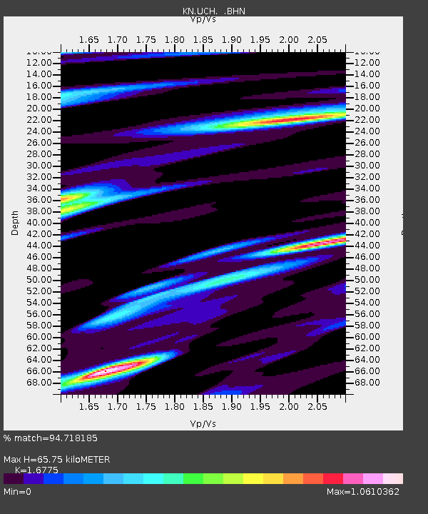
| Estimated Moho Depth: |
65.75 km |
| Estimated Crust Vp/Vs: |
1.68 |
| Assumed Crust Vp: |
6.306 km/s |
| Estimated Crust Vs: |
3.759 km/s |
| Estimated Crust Poisson's Ratio: |
0.22 |
|
| Radial Match: |
94.718185 % |
| Radial Bump: |
400 |
| Transverse Match: |
89.208206 % |
| Transverse Bump: |
400 |
| SOD ConfigId: |
3744 |
| Insert Time: |
2010-03-08 21:20:32.417 +0000 |
| GWidth: |
2.5 |
| Max Bumps: |
400 |
| Tol: |
0.001 |
|
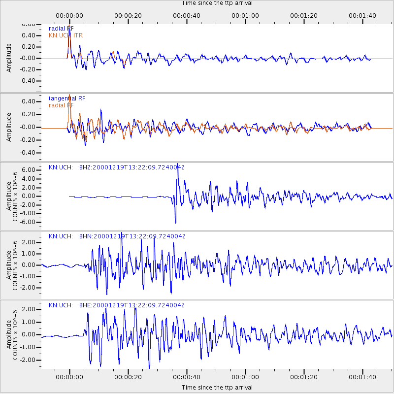
Signal To Noise
| Channel | StoN | STA | LTA |
| KN:UCH: :BHN:20001219T13:22:09.724004Z | 0.95252323 | 7.668818E-8 | 8.051056E-8 |
| KN:UCH: :BHE:20001219T13:22:09.724004Z | 0.87824994 | 7.14018E-8 | 8.130009E-8 |
| KN:UCH: :BHZ:20001219T13:22:09.724004Z | 1.6070348 | 9.727328E-8 | 6.0529665E-8 |
| Arrivals |
| Ps | 7.4 SECOND |
| PpPs | 27 SECOND |
| PsPs/PpSs | 34 SECOND |


