You are here: Home > Network List > TS - TERRAscope (Southern California Seismic Network) Stations List
> Station VTV Victorville, California, USA > Earthquake Result Viewer
VTV Victorville, California, USA - Earthquake Result Viewer
| Earthquake location: |
Vanuatu Islands |
| Earthquake latitude/longitude: |
-13.5/167.1 |
| Earthquake time(UTC): |
1996/06/10 (162) 01:04:46 GMT |
| Earthquake Depth: |
200 km |
| Earthquake Magnitude: |
5.8 MB, 5.9 MS, 6.7 UNKNOWN, 6.0 MS |
| Earthquake Catalog/Contributor: |
WHDF/NEIC |
|
| Network: |
TS TERRAscope (Southern California Seismic Network) |
| Station: |
VTV Victorville, California, USA |
| Lat/Lon: |
34.57 N/117.33 W |
| Elevation: |
847 m |
|
| Distance: |
86.0 deg |
| Az: |
53.229 deg |
| Baz: |
250.781 deg |
| Ray Param: |
0.043892637 |
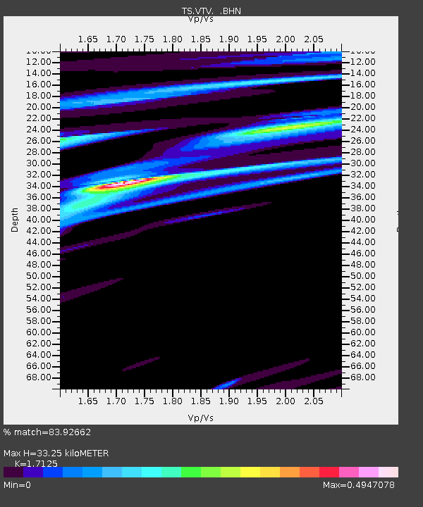
| Estimated Moho Depth: |
33.25 km |
| Estimated Crust Vp/Vs: |
1.71 |
| Assumed Crust Vp: |
6.276 km/s |
| Estimated Crust Vs: |
3.665 km/s |
| Estimated Crust Poisson's Ratio: |
0.24 |
|
| Radial Match: |
83.92662 % |
| Radial Bump: |
400 |
| Transverse Match: |
61.42026 % |
| Transverse Bump: |
400 |
| SOD ConfigId: |
6273 |
| Insert Time: |
2010-02-26 14:54:16.211 +0000 |
| GWidth: |
2.5 |
| Max Bumps: |
400 |
| Tol: |
0.001 |
|

Signal To Noise
| Channel | StoN | STA | LTA |
| TS:VTV: :BHN:19960610T01:16:33.441016Z | 1.6573141 | 4.987071E-7 | 3.0091286E-7 |
| TS:VTV: :BHE:19960610T01:16:33.441016Z | 1.1632221 | 4.140385E-7 | 3.5594104E-7 |
| TS:VTV: :BHZ:19960610T01:16:33.441016Z | 7.3364253 | 1.3586188E-6 | 1.8518811E-7 |
| Arrivals |
| Ps | 3.9 SECOND |
| PpPs | 14 SECOND |
| PsPs/PpSs | 18 SECOND |


