You are here: Home > Network List > AK - Alaska Regional Network Stations List
> Station L22K Petersville, AK, USA > Earthquake Result Viewer
L22K Petersville, AK, USA - Earthquake Result Viewer
| Earthquake location: |
Mariana Islands |
| Earthquake latitude/longitude: |
18.9/145.1 |
| Earthquake time(UTC): |
2020/06/13 (165) 21:08:30 GMT |
| Earthquake Depth: |
622 km |
| Earthquake Magnitude: |
6.2 Mww |
| Earthquake Catalog/Contributor: |
NEIC PDE/us |
|
| Network: |
AK Alaska Regional Network |
| Station: |
L22K Petersville, AK, USA |
| Lat/Lon: |
62.53 N/150.77 W |
| Elevation: |
817 m |
|
| Distance: |
61.5 deg |
| Az: |
28.351 deg |
| Baz: |
255.737 deg |
| Ray Param: |
0.058377232 |
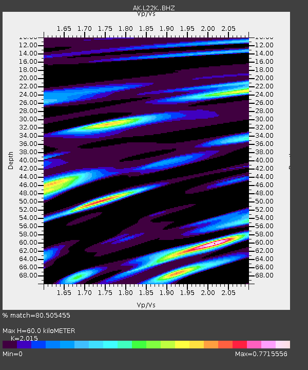
| Estimated Moho Depth: |
60.0 km |
| Estimated Crust Vp/Vs: |
2.02 |
| Assumed Crust Vp: |
6.438 km/s |
| Estimated Crust Vs: |
3.195 km/s |
| Estimated Crust Poisson's Ratio: |
0.34 |
|
| Radial Match: |
80.505455 % |
| Radial Bump: |
361 |
| Transverse Match: |
73.37266 % |
| Transverse Bump: |
400 |
| SOD ConfigId: |
21709731 |
| Insert Time: |
2020-06-27 21:10:56.382 +0000 |
| GWidth: |
2.5 |
| Max Bumps: |
400 |
| Tol: |
0.001 |
|

Signal To Noise
| Channel | StoN | STA | LTA |
| AK:L22K: :BHZ:20200613T21:17:17.740Z | 19.263123 | 1.0791848E-6 | 5.6023357E-8 |
| AK:L22K: :BHN:20200613T21:17:17.740Z | 7.2285595 | 4.0593875E-7 | 5.6157628E-8 |
| AK:L22K: :BHE:20200613T21:17:17.740Z | 7.3960257 | 4.464619E-7 | 6.036511E-8 |
| Arrivals |
| Ps | 9.8 SECOND |
| PpPs | 27 SECOND |
| PsPs/PpSs | 37 SECOND |


