You are here: Home > Network List > AK - Alaska Regional Network Stations List
> Station P16K Nushagak River, AK, USA > Earthquake Result Viewer
P16K Nushagak River, AK, USA - Earthquake Result Viewer
| Earthquake location: |
Mariana Islands |
| Earthquake latitude/longitude: |
18.9/145.1 |
| Earthquake time(UTC): |
2020/06/13 (165) 21:08:30 GMT |
| Earthquake Depth: |
622 km |
| Earthquake Magnitude: |
6.2 Mww |
| Earthquake Catalog/Contributor: |
NEIC PDE/us |
|
| Network: |
AK Alaska Regional Network |
| Station: |
P16K Nushagak River, AK, USA |
| Lat/Lon: |
59.03 N/157.99 W |
| Elevation: |
86 m |
|
| Distance: |
57.1 deg |
| Az: |
31.064 deg |
| Baz: |
250.827 deg |
| Ray Param: |
0.061069537 |
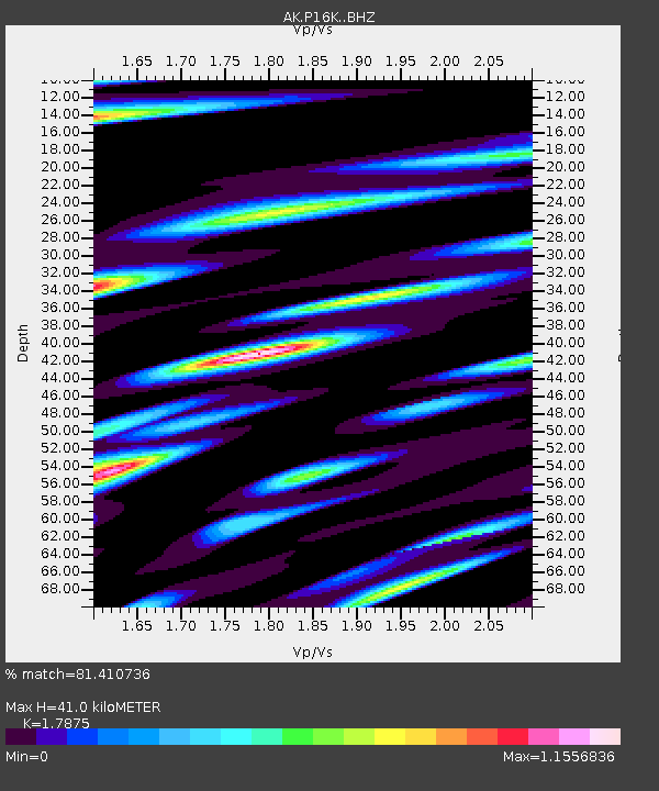
| Estimated Moho Depth: |
41.0 km |
| Estimated Crust Vp/Vs: |
1.79 |
| Assumed Crust Vp: |
6.276 km/s |
| Estimated Crust Vs: |
3.511 km/s |
| Estimated Crust Poisson's Ratio: |
0.27 |
|
| Radial Match: |
81.410736 % |
| Radial Bump: |
374 |
| Transverse Match: |
67.59294 % |
| Transverse Bump: |
400 |
| SOD ConfigId: |
21709731 |
| Insert Time: |
2020-06-27 21:11:24.534 +0000 |
| GWidth: |
2.5 |
| Max Bumps: |
400 |
| Tol: |
0.001 |
|

Signal To Noise
| Channel | StoN | STA | LTA |
| AK:P16K: :BHZ:20200613T21:16:48.620004Z | 21.560566 | 1.9293711E-6 | 8.948611E-8 |
| AK:P16K: :BHN:20200613T21:16:48.620004Z | 2.306674 | 5.9969835E-7 | 2.59984E-7 |
| AK:P16K: :BHE:20200613T21:16:48.620004Z | 8.913643 | 1.3327178E-6 | 1.4951438E-7 |
| Arrivals |
| Ps | 5.4 SECOND |
| PpPs | 17 SECOND |
| PsPs/PpSs | 23 SECOND |


