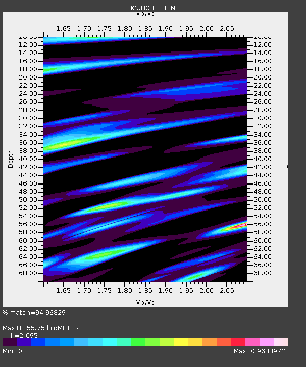
UCH KN.UCH - Earthquake Result Viewer
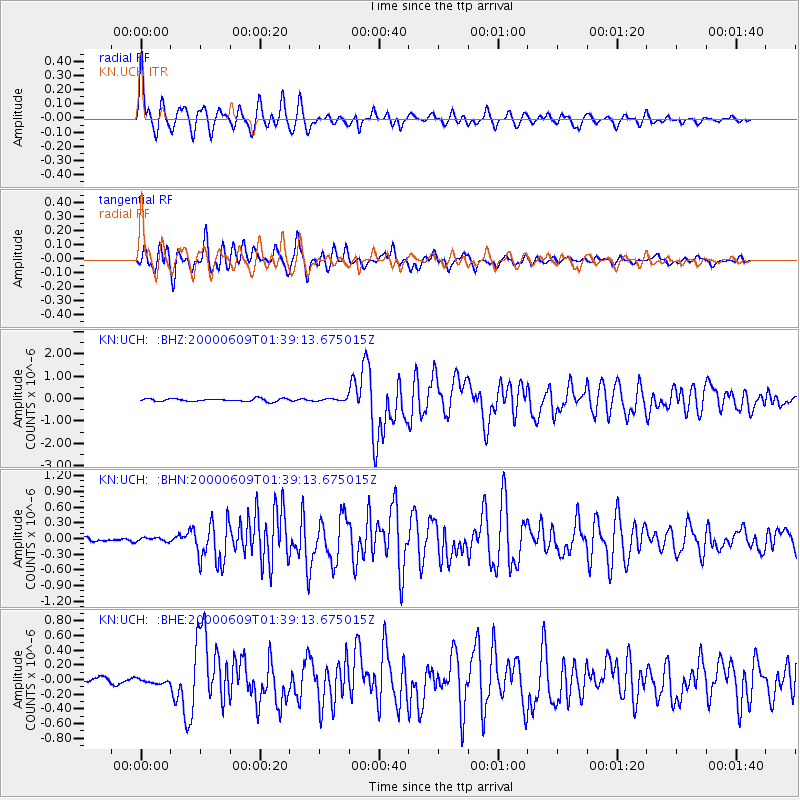
Earthquake location: New Britain Region, P.N.G.
Earthquake latitude/longitude: -5.1/152.5
Earthquake time(UTC): 2000/06/09 (161) 01:27:15 GMT
Earthquake Depth: 33 km
Earthquake Magnitude: 5.4 MB, 6.3 MS, 6.3 MW, 6.3 MW
Earthquake Catalog/Contributor: WHDF/NEIC
Network: KN Kyrgyz Seismic Telemetry Network
Station: UCH KN.UCH
Lat/Lon: 42.23 N/74.51 E
Elevation: 3850 m
Distance: 84.5 deg
Az: 313.133 deg
Baz: 101.832 deg
Ray Param: 0.045370646
Estimated Moho Depth: 55.75 km
Estimated Crust Vp/Vs: 2.10
Assumed Crust Vp: 6.306 km/s
Estimated Crust Vs: 3.01 km/s
Estimated Crust Poisson's Ratio: 0.35
Radial Match: 94.96829 %
Radial Bump: 400
Transverse Match: 95.382416 %
Transverse Bump: 400
SOD ConfigId: 3744
Insert Time: 2010-03-08 21:20:53.929 +0000
GWidth: 2.5
Max Bumps: 400
Tol: 0.001

Signal To Noise

ChannelStoNSTALTA
KN:UCH: :BHN:20000609T01:39:13.675015Z1.45922393.7168256E-82.5471252E-8
KN:UCH: :BHE:20000609T01:39:13.675015Z0.998271053.4551675E-83.4611517E-8
KN:UCH: :BHZ:20000609T01:39:13.675015Z0.94296735.735685E-86.082591E-8
Arrivals
Ps9.9 SECOND
PpPs27 SECOND
PsPs/PpSs37 SECOND