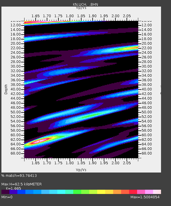
UCH KN.UCH - Earthquake Result Viewer
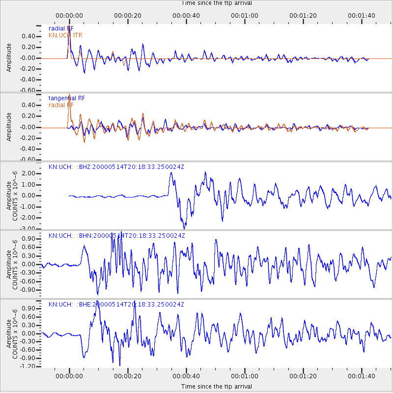
Earthquake location: Banda Sea
Earthquake latitude/longitude: -4.3/123.2
Earthquake time(UTC): 2000/05/14 (135) 20:08:34 GMT
Earthquake Depth: 33 km
Earthquake Magnitude: 5.9 MB, 5.9 MS, 6.3 MW, 6.2 MW
Earthquake Catalog/Contributor: WHDF/NEIC
Network: KN Kyrgyz Seismic Telemetry Network
Station: UCH KN.UCH
Lat/Lon: 42.23 N/74.51 E
Elevation: 3850 m
Distance: 63.9 deg
Az: 321.631 deg
Baz: 123.549 deg
Ray Param: 0.059201278
Estimated Moho Depth: 62.5 km
Estimated Crust Vp/Vs: 1.66
Assumed Crust Vp: 6.306 km/s
Estimated Crust Vs: 3.787 km/s
Estimated Crust Poisson's Ratio: 0.22
Radial Match: 93.76413 %
Radial Bump: 400
Transverse Match: 83.26477 %
Transverse Bump: 400
SOD ConfigId: 3744
Insert Time: 2010-03-08 21:20:57.514 +0000
GWidth: 2.5
Max Bumps: 400
Tol: 0.001

Signal To Noise

ChannelStoNSTALTA
KN:UCH: :BHN:20000514T20:18:33.250024Z4.02479551.7204792E-74.2746997E-8
KN:UCH: :BHE:20000514T20:18:33.250024Z5.894442.2994769E-73.9010946E-8
KN:UCH: :BHZ:20000514T20:18:33.250024Z11.5075226.646229E-75.775552E-8
Arrivals
Ps6.9 SECOND
PpPs25 SECOND
PsPs/PpSs32 SECOND