You are here: Home > Network List > KN - Kyrgyz Seismic Telemetry Network Stations List
> Station UCH KN.UCH > Earthquake Result Viewer
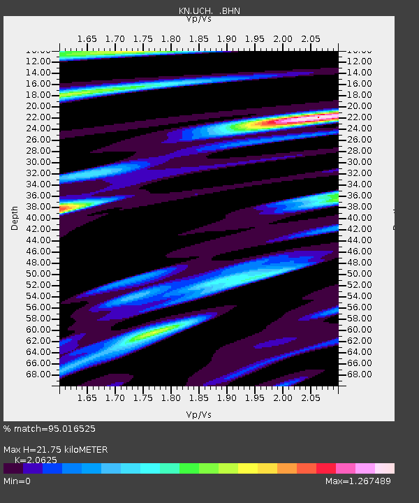
UCH KN.UCH - Earthquake Result Viewer
| Earthquake location: |
Talaud Islands, Indonesia |
| Earthquake latitude/longitude: |
4.1/125.6 |
| Earthquake time(UTC): |
2000/04/03 (094) 15:20:01 GMT |
| Earthquake Depth: |
150 km |
| Earthquake Magnitude: |
5.9 MB, 6.2 MW, 6.0 MW |
| Earthquake Catalog/Contributor: |
WHDF/NEIC |
|
| Network: |
KN Kyrgyz Seismic Telemetry Network |
| Station: |
UCH KN.UCH |
| Lat/Lon: |
42.23 N/74.51 E |
| Elevation: |
3850 m |
|
| Distance: |
59.2 deg |
| Az: |
317.688 deg |
| Baz: |
115.3 deg |
| Ray Param: |
0.061903484 |
| Estimated Moho Depth: |
21.75 km |
| Estimated Crust Vp/Vs: |
2.06 |
| Assumed Crust Vp: |
6.306 km/s |
| Estimated Crust Vs: |
3.057 km/s |
| Estimated Crust Poisson's Ratio: |
0.35 |
|
| Radial Match: |
95.016525 % |
| Radial Bump: |
400 |
| Transverse Match: |
90.31161 % |
| Transverse Bump: |
400 |
| SOD ConfigId: |
3744 |
| Insert Time: |
2010-03-08 21:21:02.527 +0000 |
| GWidth: |
2.5 |
| Max Bumps: |
400 |
| Tol: |
0.001 |
|

Signal To Noise
| Channel | StoN | STA | LTA |
| KN:UCH: :BHN:20000403T15:29:16.300007Z | 5.8611636 | 2.4442144E-7 | 4.1701863E-8 |
| KN:UCH: :BHE:20000403T15:29:16.300007Z | 14.18609 | 4.915719E-7 | 3.465168E-8 |
| KN:UCH: :BHZ:20000403T15:29:16.300007Z | 22.703245 | 1.3846869E-6 | 6.099071E-8 |
| Arrivals |
| Ps | 3.8 SECOND |
| PpPs | 10 SECOND |
| PsPs/PpSs | 14 SECOND |


