You are here: Home > Network List > AV - Alaska Volcano Observatory Stations List
> Station KAWH Katmai, Alaska > Earthquake Result Viewer
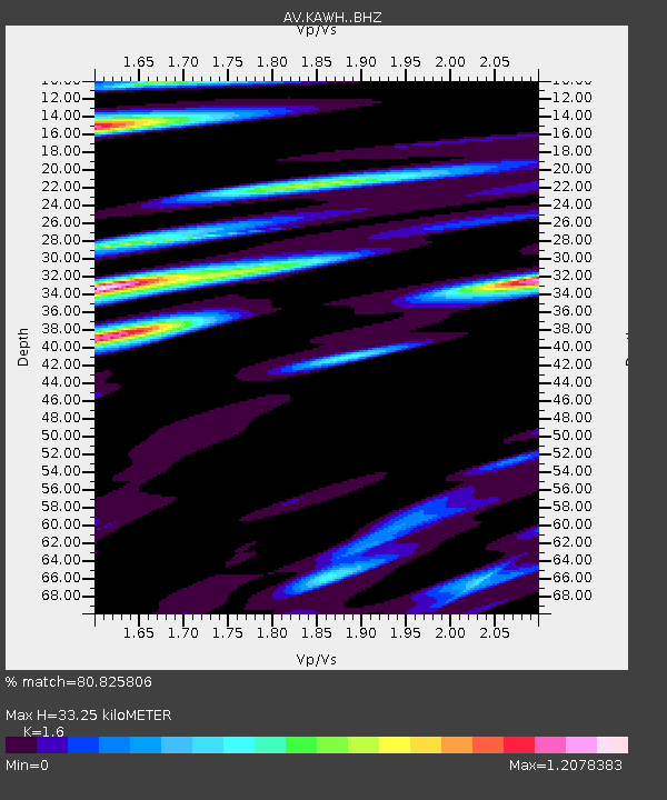
KAWH Katmai, Alaska - Earthquake Result Viewer
| Earthquake location: |
Mariana Islands |
| Earthquake latitude/longitude: |
18.9/145.1 |
| Earthquake time(UTC): |
2020/06/13 (165) 21:08:30 GMT |
| Earthquake Depth: |
622 km |
| Earthquake Magnitude: |
6.2 Mww |
| Earthquake Catalog/Contributor: |
NEIC PDE/us |
|
| Network: |
AV Alaska Volcano Observatory |
| Station: |
KAWH Katmai, Alaska |
| Lat/Lon: |
58.38 N/154.80 W |
| Elevation: |
777 m |
|
| Distance: |
58.5 deg |
| Az: |
32.388 deg |
| Baz: |
254.254 deg |
| Ray Param: |
0.060216743 |
| Estimated Moho Depth: |
33.25 km |
| Estimated Crust Vp/Vs: |
1.60 |
| Assumed Crust Vp: |
6.438 km/s |
| Estimated Crust Vs: |
4.024 km/s |
| Estimated Crust Poisson's Ratio: |
0.18 |
|
| Radial Match: |
80.825806 % |
| Radial Bump: |
400 |
| Transverse Match: |
57.20909 % |
| Transverse Bump: |
400 |
| SOD ConfigId: |
21709731 |
| Insert Time: |
2020-06-27 21:14:23.715 +0000 |
| GWidth: |
2.5 |
| Max Bumps: |
400 |
| Tol: |
0.001 |
|

Signal To Noise
| Channel | StoN | STA | LTA |
| AV:KAWH: :BHZ:20200613T21:16:57.97999Z | 14.825183 | 4.9980207E-7 | 3.3713047E-8 |
| AV:KAWH: :BHN:20200613T21:16:57.97999Z | 4.8358884 | 1.8718339E-7 | 3.8707135E-8 |
| AV:KAWH: :BHE:20200613T21:16:57.97999Z | 8.256045 | 2.8675694E-7 | 3.4732967E-8 |
| Arrivals |
| Ps | 3.3 SECOND |
| PpPs | 13 SECOND |
| PsPs/PpSs | 16 SECOND |


