You are here: Home > Network List > KN - Kyrgyz Seismic Telemetry Network Stations List
> Station UCH KN.UCH > Earthquake Result Viewer
UCH KN.UCH - Earthquake Result Viewer

| Earthquake location: |
Java Sea |
| Earthquake latitude/longitude: |
-5.7/110.8 |
| Earthquake time(UTC): |
1997/07/11 (192) 09:55:12 GMT |
| Earthquake Depth: |
574 km |
| Earthquake Magnitude: |
5.6 MB |
| Earthquake Catalog/Contributor: |
WHDF/NEIC |
|
| Network: |
KN Kyrgyz Seismic Telemetry Network |
| Station: |
UCH KN.UCH |
| Lat/Lon: |
42.23 N/74.51 E |
| Elevation: |
3850 m |
|
| Distance: |
58.0 deg |
| Az: |
328.787 deg |
| Baz: |
136.027 deg |
| Ray Param: |
0.060764387 |
| Estimated Moho Depth: |
54.75 km |
| Estimated Crust Vp/Vs: |
1.73 |
| Assumed Crust Vp: |
6.306 km/s |
| Estimated Crust Vs: |
3.656 km/s |
| Estimated Crust Poisson's Ratio: |
0.25 |
|
| Radial Match: |
98.484924 % |
| Radial Bump: |
165 |
| Transverse Match: |
97.28764 % |
| Transverse Bump: |
226 |
| SOD ConfigId: |
4480 |
| Insert Time: |
2010-03-08 21:21:32.176 +0000 |
| GWidth: |
2.5 |
| Max Bumps: |
400 |
| Tol: |
0.001 |
|
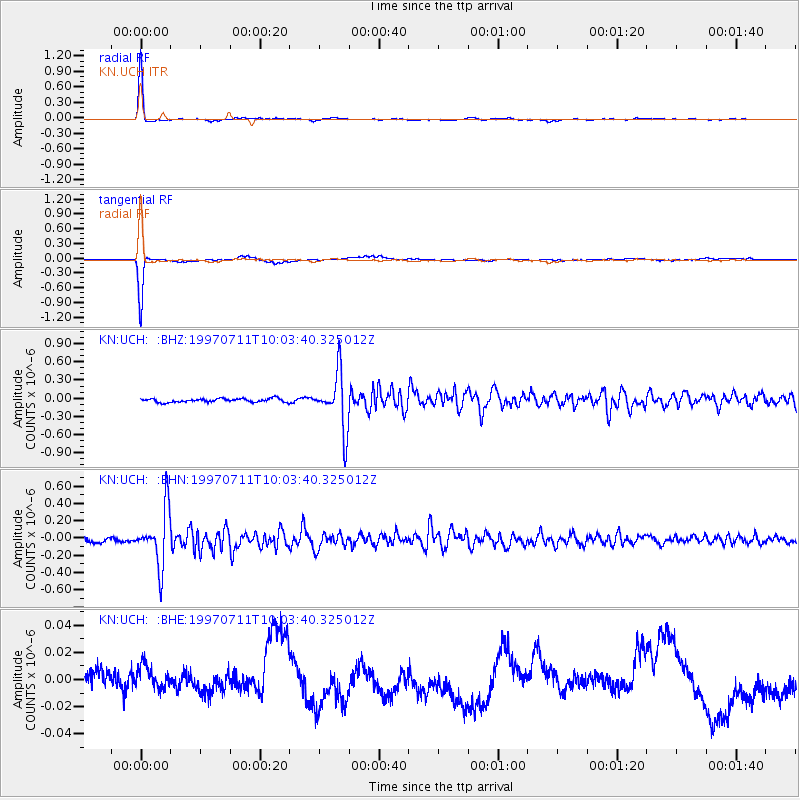
Signal To Noise
| Channel | StoN | STA | LTA |
| KN:UCH: :BHN:19970711T10:03:40.325012Z | 11.139191 | 3.239414E-7 | 2.9081233E-8 |
| KN:UCH: :BHE:19970711T10:03:40.325012Z | 0.9487125 | 8.2601295E-9 | 8.706673E-9 |
| KN:UCH: :BHZ:19970711T10:03:40.325012Z | 15.946717 | 4.595146E-7 | 2.8815624E-8 |
| Arrivals |
| Ps | 6.6 SECOND |
| PpPs | 23 SECOND |
| PsPs/PpSs | 29 SECOND |


