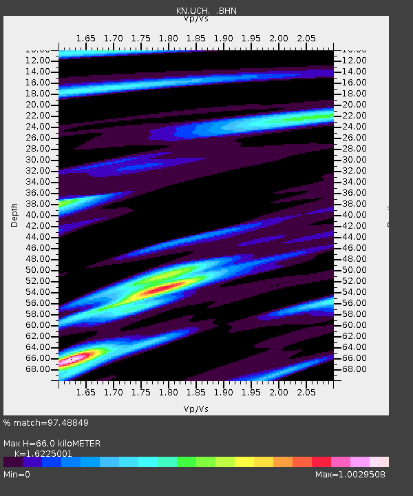
UCH KN.UCH - Earthquake Result Viewer

Earthquake location: New Britain Region, P.N.G.
Earthquake latitude/longitude: -5.6/149.6
Earthquake time(UTC): 1999/04/05 (095) 11:08:04 GMT
Earthquake Depth: 150 km
Earthquake Magnitude: 6.2 MB, 7.0 MS, 7.4 MW, 7.3 ME
Earthquake Catalog/Contributor: WHDF/NEIC
Network: KN Kyrgyz Seismic Telemetry Network
Station: UCH KN.UCH
Lat/Lon: 42.23 N/74.51 E
Elevation: 3850 m
Distance: 82.8 deg
Az: 313.668 deg
Baz: 104.224 deg
Ray Param: 0.046309564
Estimated Moho Depth: 66.0 km
Estimated Crust Vp/Vs: 1.62
Assumed Crust Vp: 6.306 km/s
Estimated Crust Vs: 3.887 km/s
Estimated Crust Poisson's Ratio: 0.19
Radial Match: 97.48849 %
Radial Bump: 400
Transverse Match: 93.97631 %
Transverse Bump: 400
SOD ConfigId: 4480
Insert Time: 2010-03-08 21:21:42.621 +0000
GWidth: 2.5
Max Bumps: 400
Tol: 0.001

Signal To Noise

ChannelStoNSTALTA
KN:UCH: :BHN:19990405T11:19:40.125Z2.3882194.4680087E-71.8708536E-7
KN:UCH: :BHE:19990405T11:19:40.125Z1.3257955.5066536E-84.153473E-8
KN:UCH: :BHZ:19990405T11:19:40.125Z2.26581382.390248E-71.05491814E-7
Arrivals
Ps6.7 SECOND
PpPs27 SECOND
PsPs/PpSs33 SECOND