You are here: Home > Network List > CI - Caltech Regional Seismic Network Stations List
> Station MUR Murrieta > Earthquake Result Viewer
MUR Murrieta - Earthquake Result Viewer
*The percent match for this event was below the threshold and hence no stack was calculated.
| Earthquake location: |
Mariana Islands |
| Earthquake latitude/longitude: |
18.9/145.1 |
| Earthquake time(UTC): |
2020/06/13 (165) 21:08:30 GMT |
| Earthquake Depth: |
622 km |
| Earthquake Magnitude: |
6.2 Mww |
| Earthquake Catalog/Contributor: |
NEIC PDE/us |
|
| Network: |
CI Caltech Regional Seismic Network |
| Station: |
MUR Murrieta |
| Lat/Lon: |
33.60 N/117.20 W |
| Elevation: |
562 m |
|
| Distance: |
85.9 deg |
| Az: |
56.023 deg |
| Baz: |
289.867 deg |
| Ray Param: |
$rayparam |
*The percent match for this event was below the threshold and hence was not used in the summary stack. |
|
| Radial Match: |
48.6168 % |
| Radial Bump: |
400 |
| Transverse Match: |
58.4719 % |
| Transverse Bump: |
400 |
| SOD ConfigId: |
21709731 |
| Insert Time: |
2020-06-27 21:18:26.537 +0000 |
| GWidth: |
2.5 |
| Max Bumps: |
400 |
| Tol: |
0.001 |
|
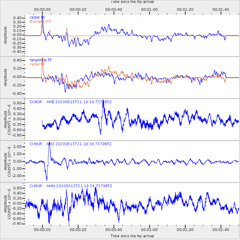
Signal To Noise
| Channel | StoN | STA | LTA |
| CI:MUR: :HHZ:20200613T21:19:34.737985Z | 9.73011 | 1.3529849E-6 | 1.3905135E-7 |
| CI:MUR: :HHN:20200613T21:19:34.737985Z | 2.174492 | 3.9542897E-7 | 1.8184892E-7 |
| CI:MUR: :HHE:20200613T21:19:34.737985Z | 2.1030898 | 5.2115115E-7 | 2.478026E-7 |
| Arrivals |
| Ps | |
| PpPs | |
| PsPs/PpSs | |


