You are here: Home > Network List > TS - TERRAscope (Southern California Seismic Network) Stations List
> Station VTV Victorville, California, USA > Earthquake Result Viewer
VTV Victorville, California, USA - Earthquake Result Viewer

| Earthquake location: |
Near Coast Of Nicaragua |
| Earthquake latitude/longitude: |
11.7/-86.9 |
| Earthquake time(UTC): |
1996/03/03 (063) 14:55:11 GMT |
| Earthquake Depth: |
33 km |
| Earthquake Magnitude: |
5.7 MB, 6.5 MS, 6.8 UNKNOWN, 6.4 MS |
| Earthquake Catalog/Contributor: |
WHDF/NEIC |
|
| Network: |
TS TERRAscope (Southern California Seismic Network) |
| Station: |
VTV Victorville, California, USA |
| Lat/Lon: |
34.57 N/117.33 W |
| Elevation: |
847 m |
|
| Distance: |
35.9 deg |
| Az: |
314.444 deg |
| Baz: |
122.058 deg |
| Ray Param: |
0.07691625 |
| Estimated Moho Depth: |
33.5 km |
| Estimated Crust Vp/Vs: |
1.70 |
| Assumed Crust Vp: |
6.276 km/s |
| Estimated Crust Vs: |
3.703 km/s |
| Estimated Crust Poisson's Ratio: |
0.23 |
|
| Radial Match: |
87.26295 % |
| Radial Bump: |
308 |
| Transverse Match: |
72.56003 % |
| Transverse Bump: |
400 |
| SOD ConfigId: |
6273 |
| Insert Time: |
2010-02-26 14:54:20.023 +0000 |
| GWidth: |
2.5 |
| Max Bumps: |
400 |
| Tol: |
0.001 |
|
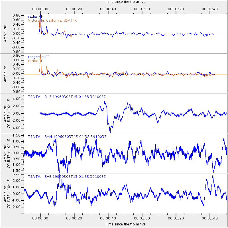
Signal To Noise
| Channel | StoN | STA | LTA |
| TS:VTV: :BHN:19960303T15:01:38.391003Z | 1.2022638 | 2.731796E-7 | 2.2722101E-7 |
| TS:VTV: :BHE:19960303T15:01:38.391003Z | 1.0390196 | 4.0526947E-7 | 3.900499E-7 |
| TS:VTV: :BHZ:19960303T15:01:38.391003Z | 3.4064245 | 6.8304814E-7 | 2.0051762E-7 |
| Arrivals |
| Ps | 4.0 SECOND |
| PpPs | 13 SECOND |
| PsPs/PpSs | 17 SECOND |


