You are here: Home > Network List > GO - National Seismic Network of Georgia Stations List
> Station TBLG Delisi, Georgia > Earthquake Result Viewer
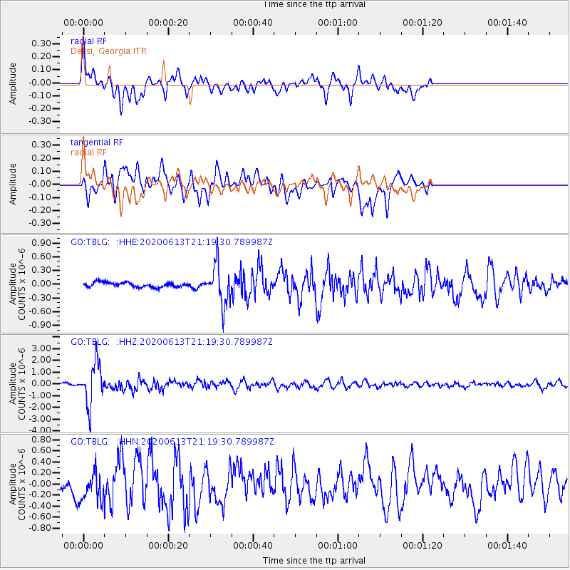
TBLG Delisi, Georgia - Earthquake Result Viewer
*The percent match for this event was below the threshold and hence no stack was calculated.
| Earthquake location: |
Mariana Islands |
| Earthquake latitude/longitude: |
18.9/145.1 |
| Earthquake time(UTC): |
2020/06/13 (165) 21:08:30 GMT |
| Earthquake Depth: |
622 km |
| Earthquake Magnitude: |
6.2 Mww |
| Earthquake Catalog/Contributor: |
NEIC PDE/us |
|
| Network: |
GO National Seismic Network of Georgia |
| Station: |
TBLG Delisi, Georgia |
| Lat/Lon: |
41.73 N/44.74 E |
| Elevation: |
510 m |
|
| Distance: |
85.1 deg |
| Az: |
312.352 deg |
| Baz: |
69.161 deg |
| Ray Param: |
$rayparam |
*The percent match for this event was below the threshold and hence was not used in the summary stack. |
|
| Radial Match: |
74.17945 % |
| Radial Bump: |
400 |
| Transverse Match: |
67.97353 % |
| Transverse Bump: |
400 |
| SOD ConfigId: |
21709731 |
| Insert Time: |
2020-06-27 21:21:36.646 +0000 |
| GWidth: |
2.5 |
| Max Bumps: |
400 |
| Tol: |
0.001 |
|
Signal To Noise
| Channel | StoN | STA | LTA |
| GO:TBLG: :HHZ:20200613T21:19:30.789987Z | 28.94537 | 1.819202E-6 | 6.28495E-8 |
| GO:TBLG: :HHN:20200613T21:19:30.789987Z | 1.4454186 | 2.5682053E-7 | 1.7767901E-7 |
| GO:TBLG: :HHE:20200613T21:19:30.789987Z | 9.054675 | 4.5479612E-7 | 5.022777E-8 |
| Arrivals |
| Ps | |
| PpPs | |
| PsPs/PpSs | |


