You are here: Home > Network List > II - Global Seismograph Network (GSN - IRIS/IDA) Stations List
> Station PFO Pinon Flat, California, USA > Earthquake Result Viewer
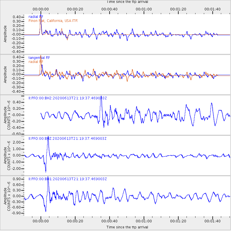
PFO Pinon Flat, California, USA - Earthquake Result Viewer
*The percent match for this event was below the threshold and hence no stack was calculated.
| Earthquake location: |
Mariana Islands |
| Earthquake latitude/longitude: |
18.9/145.1 |
| Earthquake time(UTC): |
2020/06/13 (165) 21:08:30 GMT |
| Earthquake Depth: |
622 km |
| Earthquake Magnitude: |
6.2 Mww |
| Earthquake Catalog/Contributor: |
NEIC PDE/us |
|
| Network: |
II Global Seismograph Network (GSN - IRIS/IDA) |
| Station: |
PFO Pinon Flat, California, USA |
| Lat/Lon: |
33.61 N/116.46 W |
| Elevation: |
1280 m |
|
| Distance: |
86.5 deg |
| Az: |
55.801 deg |
| Baz: |
290.26 deg |
| Ray Param: |
$rayparam |
*The percent match for this event was below the threshold and hence was not used in the summary stack. |
|
| Radial Match: |
78.16381 % |
| Radial Bump: |
400 |
| Transverse Match: |
73.19132 % |
| Transverse Bump: |
270 |
| SOD ConfigId: |
21709731 |
| Insert Time: |
2020-06-27 21:22:27.573 +0000 |
| GWidth: |
2.5 |
| Max Bumps: |
400 |
| Tol: |
0.001 |
|
Signal To Noise
| Channel | StoN | STA | LTA |
| II:PFO:00:BHZ:20200613T21:19:37.469003Z | 8.298656 | 1.2640573E-6 | 1.5232072E-7 |
| II:PFO:00:BH1:20200613T21:19:37.469003Z | 4.3845377 | 4.4309394E-7 | 1.01058305E-7 |
| II:PFO:00:BH2:20200613T21:19:37.469003Z | 1.846938 | 1.4072486E-7 | 7.61936E-8 |
| Arrivals |
| Ps | |
| PpPs | |
| PsPs/PpSs | |


